Approximate Location Map
Large Map »
Latitude: 54.7987 / 54°47'55"N
Longitude: -1.5385 / 1°32'18"W
OS Eastings: 429764
OS Northings: 544969
OS Grid: NZ297449
Mapcode National: GBR KDPY.QL
Mapcode Global: WHC4K.BNL2
Plus Code: 9C6WQFX6+FH
Entry Name: Belmont Viaduct
Listing Date: 14 January 1988
Grade: II
Source: Historic England
Source ID: 1120726
English Heritage Legacy ID: 110008
Also known as: Belmont railway viaduct
Brassside viaduct
ID on this website: 101120726
Location: County Durham, DH1
County: County Durham
Civil Parish: Framwellgate Moor
Traditional County: Durham
Lieutenancy Area (Ceremonial County): County Durham
Church of England Parish: Newton Hall LEP
Church of England Diocese: Durham
Tagged with: Railway viaduct
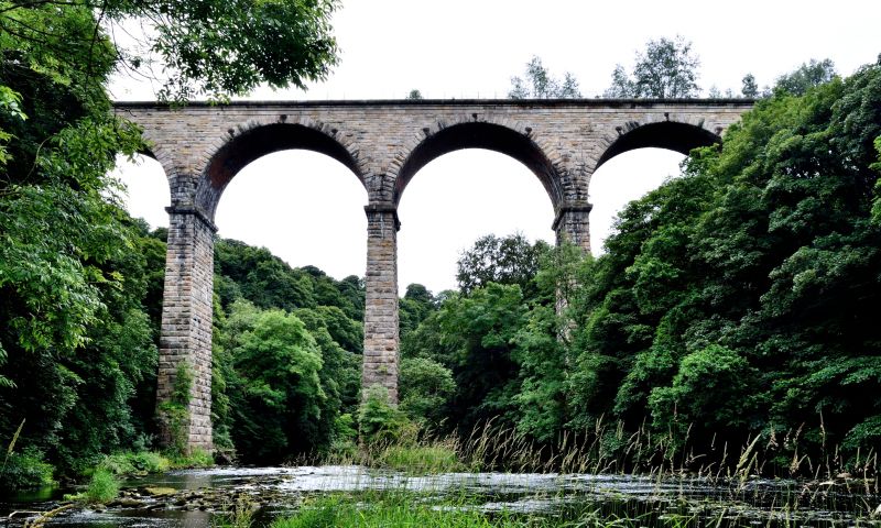
BELMONT RIVER WEAR
NZ 24 SE
6/18 Belmont Viaduct
II
Railway viaduct. 1856 for Auckland branch of North Eastern Railway. Builder
Cail of Newcastle. Speech by Cail gives'Mr. Hodgson' as the engineer for the
branch. Rock-faced sandstone, some from Rudchester, and brick, with ashlar
dressings and cast-iron tie-rods. 130 ft. high; 8 segmental arches, on
tapered piers with impost bands, have stepped voussoirs and brick soffits.
3 tallest arches, 2 in river and one on east shore, have apsidal cutwaters.
Low wall in same materials in southernmost arch; corresponding arch on north
not inspected. 4 tallest arches have elliptical cast iron tie-ends above
voussoirs, with star-shaped ribs. Bull-nosed parapet on top cornice continues
round paired wide pilasters at each end, with low pyramidal coping. An
important landscape feature.
Source: Proceedings of the Society of Antiquaries of Newcastle upon Tyne,Vol.1,
No. 18, for 1856; Newcastle 1915 reprint of Gateshead 1858, p.137.
Listing NGR: NZ2976444969
External links are from the relevant listing authority and, where applicable, Wikidata. Wikidata IDs may be related buildings as well as this specific building. If you want to add or update a link, you will need to do so by editing the Wikidata entry.


Other nearby listed buildings
