Approximate Location Map
Large Map »
Latitude: 54.8179 / 54°49'4"N
Longitude: -1.542 / 1°32'31"W
OS Eastings: 429530
OS Northings: 547106
OS Grid: NZ295471
Mapcode National: GBR KDNQ.ZP
Mapcode Global: WHC4K.85ZB
Plus Code: 9C6WRF95+56
Entry Name: Barn and Gin-Gang 100 Metres South West of Finchale Abbey Farmhouse
Listing Date: 14 January 1988
Grade: II
Source: Historic England
Source ID: 1159374
English Heritage Legacy ID: 110011
ID on this website: 101159374
Location: County Durham, DH1
County: County Durham
Civil Parish: Framwellgate Moor
Traditional County: Durham
Lieutenancy Area (Ceremonial County): County Durham
Church of England Parish: Durham St Oswald
Church of England Diocese: Durham
Tagged with: Barn
FRAMWELLGATE MOOR FINCHALE AVENUE
NZ 24 NE
(North side, off)
2/21 Barn and gin-gang
100m south-west of
Finchale Abbey
farmhouse
GV II
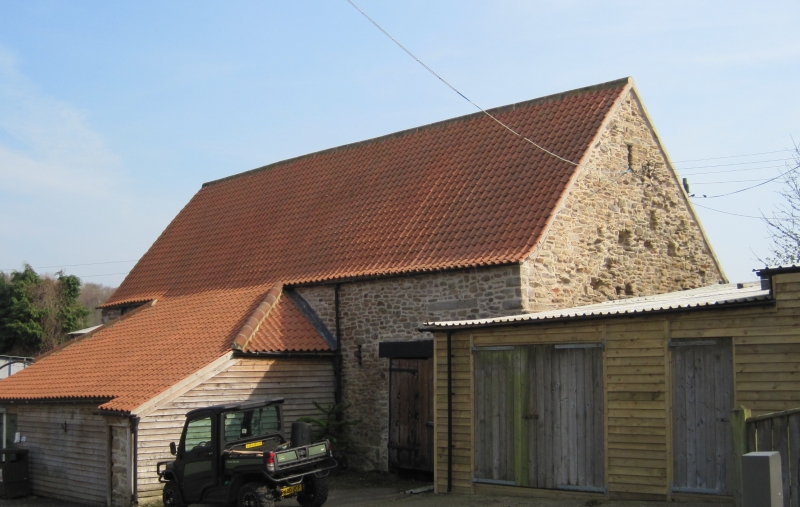
Barn and gin-gang. Probably C17 incorporating medieval fabric; C18 and C19
alterations. Thinly-rendered sandstone rubble with quoins and ashlar dressings;
roof of pantiles. One high storey, 5 bays and low front extension; gin-gang
to rear. Old wood lintels, supplemented by newer beams, over wide opposed
threshing doors with chamfered jambs; sill of door in front wall high above
present ground level. Both doors partly blocked and with smaller boarded doors
inserted under wood lintels. C19 front extension has half-hipped catslide
roof on rubble piers, blocked with C20 shuttering. Left return has door,
with sill above ground level, under old wood lintel; 3 tiered vent-slits in
gable peak, distributed with axis to rear of present gable centre. Right
return gable shows 5 holes for purlins of demolished adjacent building, under
vent slit in gable peak. Rear elevation shows 2 rows of vent slits to right
of door; 4 low octagonal piers, probably medieval, forming gin-gang with low
walls between some; sawn-off beam in barn wall suggests gin-gang formerly
roofed. Interior shows re-used tie-beam trusses, with wedges supporting 2
rows of purlins; diagonal mortices in soffits of tie-beams for braces to wall
in former use. No ridge piece.
Listing NGR: NZ2951847106
External links are from the relevant listing authority and, where applicable, Wikidata. Wikidata IDs may be related buildings as well as this specific building. If you want to add or update a link, you will need to do so by editing the Wikidata entry.


Other nearby listed buildings
