Approximate Location Map
Large Map »
Latitude: 54.7727 / 54°46'21"N
Longitude: -1.5712 / 1°34'16"W
OS Eastings: 427684
OS Northings: 542055
OS Grid: NZ276420
Mapcode National: GBR KFG7.NX
Mapcode Global: WHC4Q.V90K
Plus Code: 9C6WQCFH+3G
Entry Name: 3 and 4A, Church Street
Listing Date: 10 March 1988
Grade: II
Source: Historic England
Source ID: 1323229
English Heritage Legacy ID: 110093
ID on this website: 101323229
Location: The Sands, County Durham, DH1
County: County Durham
Electoral Ward/Division: Elvet and Gilesgate
Parish: City of Durham
Built-Up Area: Durham
Traditional County: Durham
Lieutenancy Area (Ceremonial County): County Durham
Church of England Parish: Durham St Oswald
Church of England Diocese: Durham
Tagged with: Building
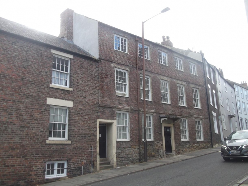
DURHAM AND FRAMWELLGATE CHURCH STREET
NZ 2742 SE (East side)
15/44 Nos. 3 and 4A
GV II
2 houses. Late C17 and early C19. English garden wall bond brick, No. 4A on
sandstone rubble plinth; Welsh slate roofs, brick stacks. No. 3 early C19.
2 storeys and basement, 2 bays. Door in wall of No. 4A. Basement windows
2-light casements (that on left C20). Other windows 16-pane sashes under flat
stone lintels. All have projecting stone sills. End chimneys. No. 4A late C17.
3 storeys, 5 bays. At left 2 steps up to 5-panel door with low overlight recessed
in stop-chamfered stone surround (No. 3). Central renewed door in stone architrave
under early C20 bracketed cornice hood. 2-brick floor bands. 16-pane near-flush
sash windows, except for 2-light casements with glazing bars on top floor.
Blocked bullseye windows at left end on upper floors. Iron reinforcing tie ends
at floor levels. Blocked boot-scraper recess by door.
Interior: Late C17 closed-string well stair.
Listing NGR: NZ2768442055
External links are from the relevant listing authority and, where applicable, Wikidata. Wikidata IDs may be related buildings as well as this specific building. If you want to add or update a link, you will need to do so by editing the Wikidata entry.


Other nearby listed buildings
