Approximate Location Map
Large Map »
Latitude: 54.5169 / 54°31'0"N
Longitude: -1.9905 / 1°59'25"W
OS Eastings: 400710
OS Northings: 513512
OS Grid: NZ007135
Mapcode National: GBR GJJ6.VL
Mapcode Global: WHB4K.DQCM
Plus Code: 9C6WG285+QQ
Entry Name: Linked Farmbuildings and Gin-Gang, Attached to South of Stone Bridge Farmhouse
Listing Date: 17 June 1986
Grade: II
Source: Historic England
Source ID: 1323063
English Heritage Legacy ID: 111161
ID on this website: 101323063
Location: County Durham, DL12
County: County Durham
Civil Parish: Bowes
Traditional County: Yorkshire
Lieutenancy Area (Ceremonial County): County Durham
Tagged with: Agricultural structure
NZ 01 SW
20/4
BOWES
A66
(South side, off)
Liked farmbuildings
and gin-gang,
attached to south
of Stone Bridge
Farmhouse
GV
II
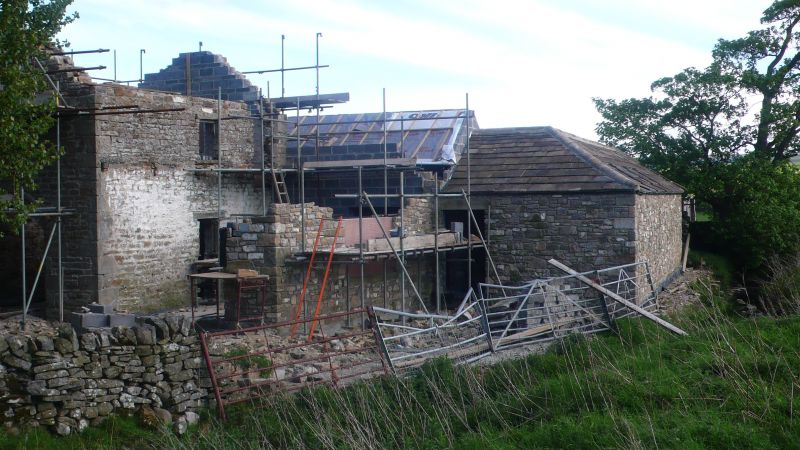
Linked farm buildings. Early-mid C19. Squared rubble and stone-flagged roofs.
H-plan with additions: former threshing barn attached to west return of farmhouse
with gin-gang to east and T-plan range of byres and north barn to west.
2-storey, 10-bay threshing barn: altered openings including 2 boarded doors to
East front; C20 vehicle entrance in gabled south return.
Large semi-octagonal gin-gang: rectangular-plan piers; later infill walls with
inserted fixed lights; semi-pyramidal roof.
T-plan, one-storey range of byres: 5-bay east range has central Dutch door,
blocked end doors and inserted window to south; 6-bay west range, at right-
angles, has round-arched opening in east front, 2 replaced Dutch doors; roof
hipped to north.
2-storey, 3-bay north barn: brick segmental archway in gabled north return;
external stone stairway to boarded door on east wall.
Listing NGR: NZ0071013512
External links are from the relevant listing authority and, where applicable, Wikidata. Wikidata IDs may be related buildings as well as this specific building. If you want to add or update a link, you will need to do so by editing the Wikidata entry.


Other nearby listed buildings
