Approximate Location Map
Large Map »
Latitude: 54.6034 / 54°36'12"N
Longitude: -1.8039 / 1°48'13"W
OS Eastings: 412766
OS Northings: 523152
OS Grid: NZ127231
Mapcode National: GBR HHV6.8L
Mapcode Global: WHC5D.8K8B
Plus Code: 9C6WJ53W+9C
Entry Name: The Folly in Raby Park
Listing Date: 14 September 1966
Grade: II*
Source: Historic England
Source ID: 1121773
English Heritage Legacy ID: 111446
ID on this website: 101121773
Location: County Durham, DL2
County: County Durham
Civil Parish: Raby with Keverstone
Traditional County: Durham
Lieutenancy Area (Ceremonial County): County Durham
Church of England Parish: Staindrop
Church of England Diocese: Durham
Tagged with: Architectural structure
RABY WITH KEVERSTONE BURNT HOUSES ROAD
NZ 12 SW
(South side, off)
9/81 The Folly in
14/9/66 Raby Park
II*
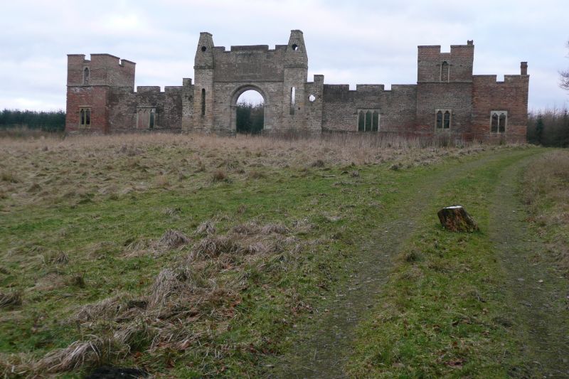
Folly to Raby Castle. 1780 by J. Carr, incorporating medieval barbican arch
and other fragments from Raby Castle. Coarse pinkish sandstone arch; other
sections rubble or brick with ashlar dressings and quoins; dense vegetation
obscures possible plinth. Gateway and 2-storey, one-bay towers linked by
walls; right one-storey, one-bay addition in similar materials and style.
Double-chamfered arch, on half-octagonal shafts with moulded capitals, in
stone wall under brick string and parapet containing window with 4 trefoil-
headed lights. Flanking turrets are rubble, and contain small openings with
monolithic round heads, below string and truncated pierced pyramids. Flanking
these are lower narrow rubble sections with quatrefoil openings. Walls, with
windows with 3 trefoil-headed lights, link to towers with 2-light ground-floor
windows and single light above in same style but with brick label moulds.
Embattled parapet. Derelict at time of survey.
Source: A. Rowan, 'Gothick Restoration at Raby' in Architectural History, 15,
1971, fig. 21b.
Listing NGR: NZ1276623152
External links are from the relevant listing authority and, where applicable, Wikidata. Wikidata IDs may be related buildings as well as this specific building. If you want to add or update a link, you will need to do so by editing the Wikidata entry.


Other nearby listed buildings
