Approximate Location Map
Large Map »
Latitude: 54.5817 / 54°34'54"N
Longitude: -1.7982 / 1°47'53"W
OS Eastings: 413138
OS Northings: 520738
OS Grid: NZ131207
Mapcode National: GBR HHWG.HC
Mapcode Global: WHC5L.B3YF
Plus Code: 9C6WH6J2+MP
Entry Name: South Entrance Gateway to Raby Castle
Listing Date: 30 September 1987
Grade: II
Source: Historic England
Source ID: 1338629
English Heritage Legacy ID: 111471
ID on this website: 101338629
Location: Staindrop, County Durham, DL2
County: County Durham
Civil Parish: Staindrop
Traditional County: Durham
Lieutenancy Area (Ceremonial County): County Durham
Church of England Parish: Staindrop
Church of England Diocese: Durham
Tagged with: Gate
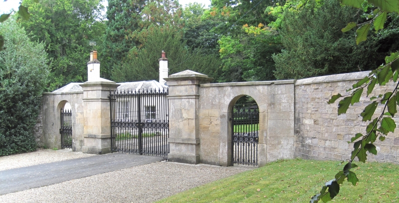
STAINDROP A 688
NZ 1320
(West side)
18/106 South entrance
gateway to
Raby Castle
GV II
Piers and pedestrian archways. Probably early C19. Sandstone ashlar. 2 tall
square piers, with plinths, top strings, cornices and low pyramidal coping,
are flanked by short stretches of flat-coped wall each containing pedestrian
arch with voussoirs. Gates removed at time of survey.
Listing NGR: NZ1313920739
External links are from the relevant listing authority and, where applicable, Wikidata. Wikidata IDs may be related buildings as well as this specific building. If you want to add or update a link, you will need to do so by editing the Wikidata entry.


Other nearby listed buildings
