Approximate Location Map
Large Map »
Latitude: 54.5405 / 54°32'25"N
Longitude: -1.7479 / 1°44'52"W
OS Eastings: 416405
OS Northings: 516166
OS Grid: NZ164161
Mapcode National: GBR JH7Y.C4
Mapcode Global: WHC5T.34XJ
Plus Code: 9C6WG7R2+5R
Entry Name: Ruins of St Lawrence's Chapel
Listing Date: 12 January 1967
Grade: II*
Source: Historic England
Source ID: 1338613
English Heritage Legacy ID: 111594
ID on this website: 101338613
Location: Gainford, County Durham, DL11
County: County Durham
Civil Parish: Barforth
Traditional County: Yorkshire
Lieutenancy Area (Ceremonial County): County Durham
Church of England Parish: Forcett with Aldborough and Melsonby
Church of England Diocese: Leeds
Tagged with: Chapel
NZ 11 NE BARFORTH BARFORTH
4/5 Ruins of St.
12.1.67 Lawrence's Chapel
GV II*
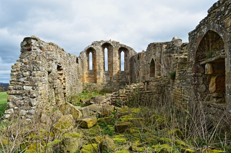
Chapel of the deserted medieval village of Barforth. C12, enlarged and
remodelled in C13; nave converted into priest's house in early C16. Rubble,
coursed in parts, with ashlar dressings. Rectangular plan.
South elevation in two sections: left part C12. Remains of original round-
arched door to left of C13 doorway with arch of 2 orders, the outer hollow-
chamfered on jamb shafts whose moulded caps and bases survive; doorway now
blocked with a C16 or later 2-light window (also blocked) inserted. To right
remains of narrow C12 loop and C16 square chamfered window. Right part of
wall, with chamfered plinth, C13: blocked trefoil-headed priest's door and 4
lancet windows. East end has stepped clasping buttresses and small central
buttress under 3 stepped lancets with linked hoodmould. North elevation
shows from east to west: lancet, round-arched low-side window, chamfered
doorway, buttress with chamfered angles and square C16 window; west part of
wall largely fallen. West end has 3 stepped buttresses, the shorter central
one below a tall lancet subdivided to serve floors of C16 priest's house.
Interior: eastern lancets have sills set low to carry reredos; rebated
trefoil-headed aumbry on north. Lower part of C16 cross wall shows jambs of
doorway, remains of fireplace, and squint from house to chapel.
Historical note: The chapel may have served a hospital or small collegiate
establishment. The priest's house was a farmhouse until the C18; its north
wall fell in the mid C19, and the cross wall in the 1960's.
Listing NGR: NZ1640516166
External links are from the relevant listing authority and, where applicable, Wikidata. Wikidata IDs may be related buildings as well as this specific building. If you want to add or update a link, you will need to do so by editing the Wikidata entry.


Other nearby listed buildings
