Approximate Location Map
Large Map »
Latitude: 54.6537 / 54°39'13"N
Longitude: -1.4513 / 1°27'4"W
OS Eastings: 435502
OS Northings: 528876
OS Grid: NZ355288
Mapcode National: GBR LG9M.LK
Mapcode Global: WHD6H.P946
Plus Code: 9C6WMG3X+FF
Entry Name: Black Lion Public House and Former Stable Wing
Listing Date: 31 October 1973
Grade: II
Source: Historic England
Source ID: 1322836
English Heritage Legacy ID: 112154
ID on this website: 101322836
Location: Sedgefield, County Durham, TS21
County: County Durham
Civil Parish: Sedgefield
Built-Up Area: Sedgefield
Traditional County: Durham
Lieutenancy Area (Ceremonial County): County Durham
Church of England Parish: Upper Skerne
Church of England Diocese: Durham
Tagged with: Pub
NZ 3528 SEDGEFIELD HIGH STREET
(North side)
13/41 Black Lion Public House
31/10/73 and former stable wing
II
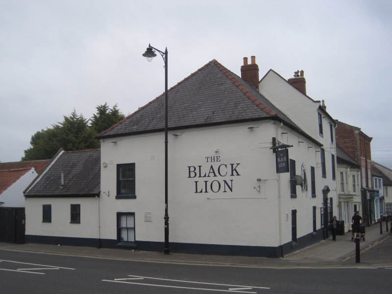
Public house with stable wing to rear. Public house of 2 builds: left section
probably early C18, right section late C18-early Cl9, late C19 alterations and
re-fenestration; early Cl9 stable wing. Rendered with renewed Welsh slate roofs
and brick chimneys; stable wing has pantiled roof.
Public house: 2-storey left section of 2 wide bays has replaced 4-pane sashes,
ground-floor windows with external shutters; long-span roof is hipped to left.
One-bay left return has similar windows. 3-storey, 2-bay right section has
4-panel door in pedimented doorcase; 4-pane sash with external shutters to right;
similar windows above without shutters. Restored, diamond-shaped sundial above
first-floor windows. Roof has late C20 raised brick verges and rebuilt end
chimneys.
2-storey, 8-bay stable wing, attached to rear of right section, has openings
under brick basket arches: 4 original Dutch doors to ground floor and blocked
openings above. 2 bays, nearest house, altered in late C20 to form kitchen.
See entry under HIGH STREET (North Side).
Listing NGR: NZ3551028882
External links are from the relevant listing authority and, where applicable, Wikidata. Wikidata IDs may be related buildings as well as this specific building. If you want to add or update a link, you will need to do so by editing the Wikidata entry.


Other nearby listed buildings
