Approximate Location Map
Large Map »
Latitude: 51.8075 / 51°48'26"N
Longitude: 0.6295 / 0°37'46"E
OS Eastings: 581377
OS Northings: 215360
OS Grid: TL813153
Mapcode National: GBR QL3.PYY
Mapcode Global: VHJJR.VTNS
Plus Code: 9F32RJ4H+XR
Entry Name: Wall to the North of Powers Hall End
Listing Date: 7 February 1973
Grade: II
Source: Historic England
Source ID: 1122555
English Heritage Legacy ID: 113578
ID on this website: 101122555
Location: Powers Hall End, Braintree, Essex, CM8
County: Essex
District: Braintree
Civil Parish: Witham
Built-Up Area: Witham
Traditional County: Essex
Lieutenancy Area (Ceremonial County): Essex
Church of England Parish: Witham St Nicolas
Church of England Diocese: Chelmsford
Tagged with: Wall
TL 8115 3/20
1841
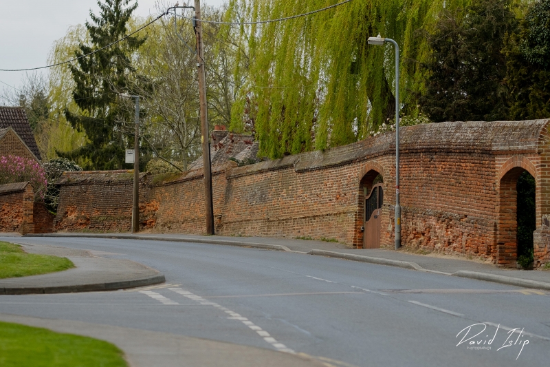
POWERS HALL END (North Side)
Wall to the north of Powers Hall End
(Formerly listed as Wall to the north of Powershall End, POWERSHALL END)
II
A C16-C17 red brick wall on the north side of Powers Hall End extending for a length of approximately 250 ft with buttresses on the inner side, north of No 26 (Stourton) qv. RCHM (53).
Listing NGR: TL8137715360
External links are from the relevant listing authority and, where applicable, Wikidata. Wikidata IDs may be related buildings as well as this specific building. If you want to add or update a link, you will need to do so by editing the Wikidata entry.


Other nearby listed buildings
