Approximate Location Map
Large Map »
Latitude: 51.9497 / 51°56'58"N
Longitude: 0.4432 / 0°26'35"E
OS Eastings: 568004
OS Northings: 230727
OS Grid: TL680307
Mapcode National: GBR NFG.QW4
Mapcode Global: VHJJ2.M8N7
Plus Code: 9F32WCXV+V7
Entry Name: Gibraltar Mill
Listing Date: 21 December 1967
Last Amended: 17 May 1985
Grade: II
Source: Historic England
Source ID: 1106360
English Heritage Legacy ID: 115334
Also known as: Gibraltar Mill, Great Bardfield
ID on this website: 101106360
Location: Bridge End, Braintree, Essex, CM7
County: Essex
District: Braintree
Civil Parish: Great Bardfield
Built-Up Area: Great Bardfield
Traditional County: Essex
Lieutenancy Area (Ceremonial County): Essex
Church of England Parish: Great Bardfield St Mary the Virgin
Church of England Diocese: Chelmsford
Tagged with: Tower mill
TL 63 NE GREAT BARDFIELD MILL ROAD
(north side)
3/195 Gibraltar Mill
21.12.67 (Formerly listed under
Outlying Items)
- II
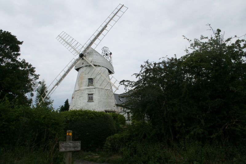
Tower windmill, now a dwelling. Early C18, converted 1934. Plastered red
brick, boarded cap. Built in 2 stages, originally octagonal to a height of 6.10
metres, later raised to 9.77 metres, reducing to a circular plan. Wall
thickness 1.20 metres at the base. Single-storey domestic extension to NE, of
plastered brick with shingled roof. 4 floors with C20 casements on each. Boat-
shaped cap, stocks and skeleton sails, fantail gear without fantail. Height
overall 13.44 metres. Farries finds the earliest documentary evidence of it in
1707, and concludes that it was built after the great storm of 1703, which
destroyed many mills, as an experimental tower mill with exceptionally massive
walls, completed soon after the sieges of Gibraltar, 1704-5. It was not
successful commercially, and was converted to a cottage, with an inserted stack
in the wall. It was converted back to a mill in 1754 and raised to its present
height. It was derelict 1899-1904 after storm damage and was then equipped with
the present fantail gear. It had one pair of stones. Some of the equipment
remains in situ. (K.G. Farries, Essex Windmills, Millers and Millwrights, vol.
3, 1984, 24-7). . .. . . .
Listing NGR: TL6800430727
External links are from the relevant listing authority and, where applicable, Wikidata. Wikidata IDs may be related buildings as well as this specific building. If you want to add or update a link, you will need to do so by editing the Wikidata entry.


Other nearby listed buildings
