Approximate Location Map
Large Map »
Latitude: 51.5272 / 51°31'37"N
Longitude: 0.4779 / 0°28'40"E
OS Eastings: 571986
OS Northings: 183830
OS Grid: TQ719838
Mapcode National: GBR PN2.7MS
Mapcode Global: VHJL1.7WJ4
Plus Code: 9F32GFGH+V5
Entry Name: Fobbing Hall
Listing Date: 10 November 1981
Grade: II
Source: Historic England
Source ID: 1147899
English Heritage Legacy ID: 119823
ID on this website: 101147899
Location: Fobbing, Thurrock, Essex, SS17
County: Thurrock
Electoral Ward/Division: Corringham and Fobbing
Parish: Non Civil Parish
Built-Up Area: Stanford-le-Hope
Traditional County: Essex
Lieutenancy Area (Ceremonial County): Essex
Church of England Parish: Fobbing
Church of England Diocese: Chelmsford
Tagged with: House
1.
5221 WHARF ROAD
Fobbing
Fobbing Hall
TQ 78 SW 7/17
II
2.
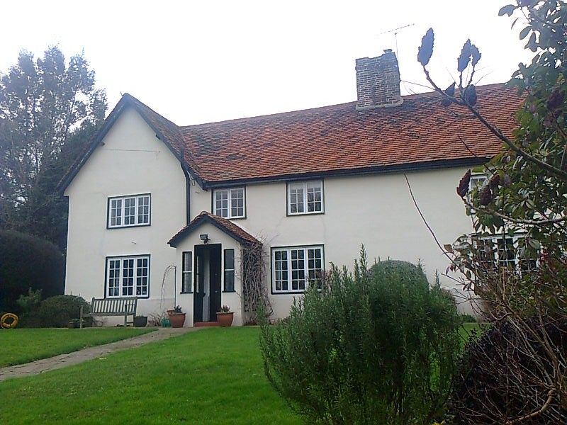
C16 house, timber-framed and plastered, with red plain tile roof. Two storeys
with gabled cross wing at south-west end. Four window range modern casements.
Modern gabled porch with red plain tile roof.
Listing NGR: TQ7198683830
External links are from the relevant listing authority and, where applicable, Wikidata. Wikidata IDs may be related buildings as well as this specific building. If you want to add or update a link, you will need to do so by editing the Wikidata entry.


Other nearby listed buildings
