Approximate Location Map
Large Map »
Latitude: 51.7988 / 51°47'55"N
Longitude: 0.2661 / 0°15'57"E
OS Eastings: 556357
OS Northings: 213557
OS Grid: TL563135
Mapcode National: GBR MFV.249
Mapcode Global: VHHM9.K1JV
Plus Code: 9F32Q7X8+GC
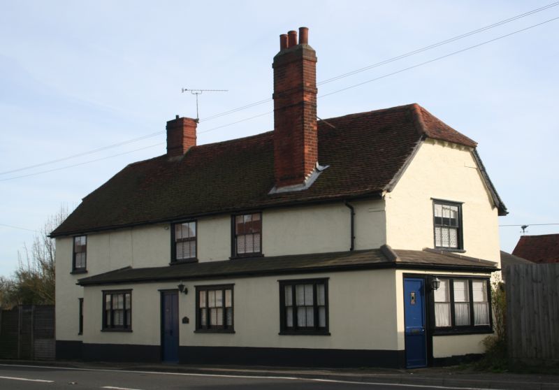
Entry Name: The Whalebone
Listing Date: 13 June 1983
Grade: II
Source: Historic England
Source ID: 1111977
English Heritage Legacy ID: 120591
ID on this website: 101111977
Location: White Roding, Uttlesford, Essex, CM6
County: Essex
District: Uttlesford
Civil Parish: White Roothing
Traditional County: Essex
Lieutenancy Area (Ceremonial County): Essex
Church of England Parish: The South Rodings
Church of England Diocese: Chelmsford
Tagged with: Building
TL51SE WHITE RODING CHELMSFORD ROAD
8/133 "The Whalebone"
II
Public House. C17 or earlier with later extensions and alterations. Timber
framed and plastered with half hipped plain red tiled roof and C20 extension
to front with hipped grey slate roof. 2 storey with 4 window range. Ground
floor 3 range 1st floor, all with sliding sashes. Off centre and forward
red brick chimney stacks.
Listing NGR: TL5635713557
External links are from the relevant listing authority and, where applicable, Wikidata. Wikidata IDs may be related buildings as well as this specific building. If you want to add or update a link, you will need to do so by editing the Wikidata entry.


Other nearby listed buildings
