Approximate Location Map
Large Map »
Latitude: 51.9888 / 51°59'19"N
Longitude: 0.1562 / 0°9'22"E
OS Eastings: 548153
OS Northings: 234456
OS Grid: TL481344
Mapcode National: GBR LB1.B97
Mapcode Global: VHHL8.N8FQ
Plus Code: 9F32X5Q4+GF
Entry Name: Applebee
Listing Date: 22 February 1980
Grade: II
Source: Historic England
Source ID: 1112517
English Heritage Legacy ID: 121389
ID on this website: 101112517
Location: Arkesden, Uttlesford, Essex, CB11
County: Essex
District: Uttlesford
Civil Parish: Arkesden
Built-Up Area: Arkesden
Traditional County: Essex
Lieutenancy Area (Ceremonial County): Essex
Church of England Parish: Arkesden St Mary the Virgin
Church of England Diocese: Chelmsford
Tagged with: Building
ARKESDEN HAMPIT ROAD
1.
5222
Appelbes
TL 4834 36/14
II GV
2.
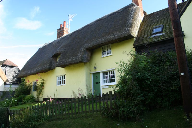
C17 timber-framed and plastered building. Renovated. Two storeys. Small
casement windows. Roof thatched, half hipped at the east end, with one dormer
window and a central chimney stack. (RCHM 4).
Listing NGR: TL4815334456
External links are from the relevant listing authority and, where applicable, Wikidata. Wikidata IDs may be related buildings as well as this specific building. If you want to add or update a link, you will need to do so by editing the Wikidata entry.


Other nearby listed buildings
