Approximate Location Map
Large Map »
Latitude: 51.9655 / 51°57'55"N
Longitude: 0.143 / 0°8'34"E
OS Eastings: 547323
OS Northings: 231837
OS Grid: TL473318
Mapcode National: GBR LB7.LZH
Mapcode Global: VHHL8.FVGM
Plus Code: 9F32X48V+55
Entry Name: Blacksmith's Cottage
Listing Date: 22 February 1980
Grade: II
Source: Historic England
Source ID: 1112456
English Heritage Legacy ID: 121557
ID on this website: 101112456
Location: Clavering, Uttlesford, Essex, CB11
County: Essex
District: Uttlesford
Civil Parish: Clavering
Built-Up Area: Clavering
Traditional County: Essex
Lieutenancy Area (Ceremonial County): Essex
Church of England Parish: Clavering St Mary and St Clement
Church of England Diocese: Chelmsford
Tagged with: Cottage
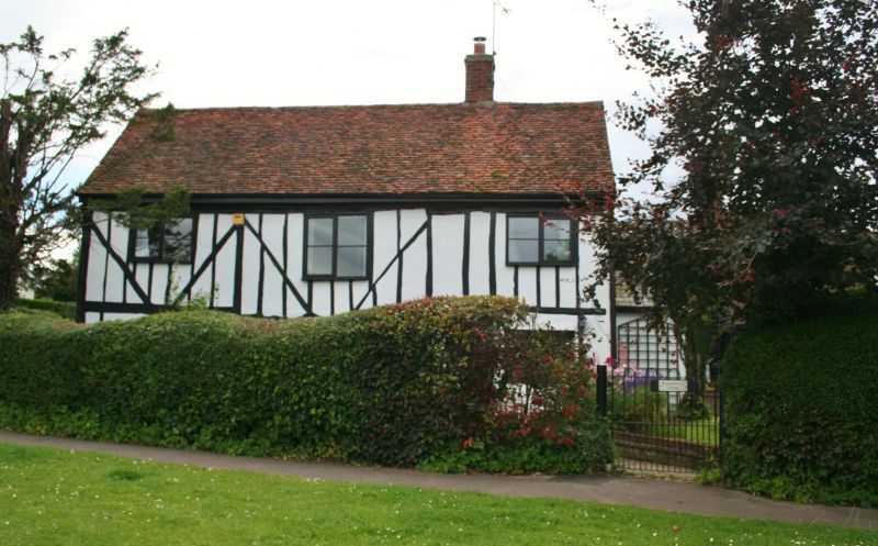
CLAVERING BLACKSMITHS CORNER
1.
5222
Blacksmith's Cottage
TL 4731 41/1017
II
2.
C17-C18 timber-framed building. Renovated, with the timber-framing exposed
on the front. Two storeys. Three window range of casements. Roof tiled.
Listing NGR: TL4732331837
External links are from the relevant listing authority and, where applicable, Wikidata. Wikidata IDs may be related buildings as well as this specific building. If you want to add or update a link, you will need to do so by editing the Wikidata entry.


Other nearby listed buildings
