Approximate Location Map
Large Map »
Latitude: 51.9898 / 51°59'23"N
Longitude: -1.7023 / 1°42'8"W
OS Eastings: 420538
OS Northings: 232418
OS Grid: SP205324
Mapcode National: GBR 4PB.8F8
Mapcode Global: VHBYZ.F7XX
Plus Code: 9C3WX7QX+W3
Entry Name: Lemington House and Boundary Wall to East and Railings to North
Listing Date: 5 March 1981
Grade: II*
Source: Historic England
Source ID: 1341717
English Heritage Legacy ID: 126726
ID on this website: 101341717
Location: Moreton-in-Marsh, Cotswold, Gloucestershire, GL56
County: Gloucestershire
District: Cotswold
Civil Parish: Moreton-in-Marsh
Built-Up Area: Moreton-in-Marsh
Traditional County: Gloucestershire
Lieutenancy Area (Ceremonial County): Gloucestershire
Church of England Parish: Moreton-in-Marsh St David
Church of England Diocese: Gloucester
Tagged with: Building
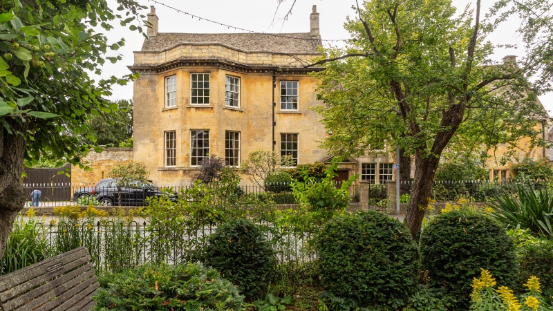
1.
5224 MORETON-IN-THE-MARSH OXFORD STREET
(south side)
Lemington House and
boundary wall to east
and railings to north
SP 2032 SE 2/42 5.3.81
II* GV
2.
Mid-late C17 remodelled in circa 1760s. Front in 2 parts both 2-storeys. West part:
dressed rubble with Cotswold stone roof and central chimney with diagonal shafts.
Fenestration altered: glazing bar sashes, in rebated surrounds for cross-mullioned
windows, one on first floor, a pair on ground floor; one earlier window blocked on
each floor to right. Pedimented doorcase to left with 6-panel door. To rear:
dormer gable, fenestration altered except attic which retains 3-light mullion
window with drip; there is a drip over the first floor windows. East part: on
basement. Ashlar with modillion cornice and parapet; ground floor cill string.
Cotswold stone roof with coped verges, later end chimneys. Main feature is full-
height 3 window bays to left, glazing bar sashes with echoing panels in parapet.
Lead rainwater head to left and 10 ft boundary wall linking with Bengal House (qv).
Spear head rails on dwarf-stone walls to road. Rear Extension: Long and T-plan
with mullion and transom windows. Interior: stairs at angle with rear wing; the
C17 wide spaced balusters survive to the upper parts, shaped handrail survives
intact, otherwise altered in mid-C19. Ground floor room of west wing has richly
moulded beams and plaster. The first floor bay window room in the east wing is
an excellent example of the period, half-panelled and with many original fittings.
One room in rear wing is fully panelled with moulded late C17 panelling. More
moulded beams to west wing in upper rooms. The roof structure of the C17 parts
is solid late C17 indicating that the rear wing post-dates the west wing; in the
former one curved collar.
Listing NGR: SP2053832418
External links are from the relevant listing authority and, where applicable, Wikidata. Wikidata IDs may be related buildings as well as this specific building. If you want to add or update a link, you will need to do so by editing the Wikidata entry.


Other nearby listed buildings
