Approximate Location Map
Large Map »
Latitude: 52.0132 / 52°0'47"N
Longitude: -1.7587 / 1°45'31"W
OS Eastings: 416654
OS Northings: 235006
OS Grid: SP166350
Mapcode National: GBR 4NW.L6D
Mapcode Global: VHB19.GNLJ
Plus Code: 9C4W267R+7G
Entry Name: Blockley Court Court House and Southview and Short Wall to South West of Court House
Listing Date: 26 August 1983
Grade: II
Source: Historic England
Source ID: 1303946
English Heritage Legacy ID: 126912
ID on this website: 101303946
Location: Blockley, Cotswold, Gloucestershire, GL56
County: Gloucestershire
District: Cotswold
Civil Parish: Blockley
Built-Up Area: Blockley
Traditional County: Gloucestershire
Lieutenancy Area (Ceremonial County): Gloucestershire
Church of England Parish: Blockley St Peter and St Paul
Church of England Diocese: Gloucester
Tagged with: Architectural structure
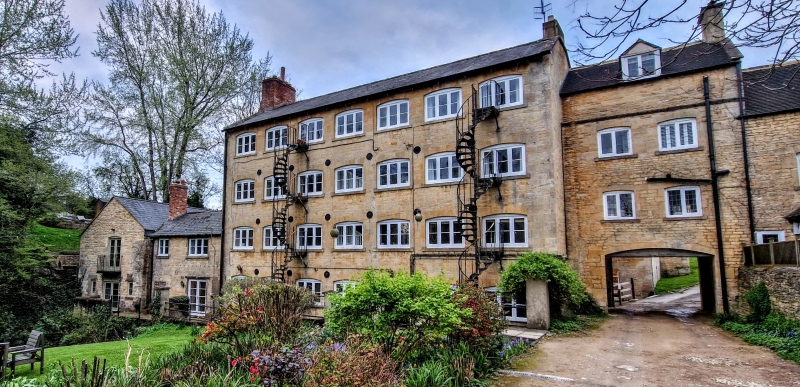
SP 1635 6/179 BLOCKLEY STATION ROAD
(South-East side)
Blockley Court:
Court House and
Southview and Short
Wall to South-West of
Court House
GV II
Formerly Westmacott's Mill. C17 origins, flourished during silk trade of C18 and
early C19. Largely mid C19 rebuilding. Court House and Southview form one of
2 parallel mums of mill buildings. Three storeys to south, 4 storeys to north.
Coursed and squared rubble, slate roofs; Court House is taller with 3 ranges of
glazing bar sashes, Southview 9 ranges of segment-headed casements. Court House has
original wooden box-porch with elliptical head entrance to right. Southview has 2
fire escapes, entered however from north side. Rear door, to basement, of Court House
with traceried fanlight. Now converted into council houses. Vestmacott's was the
largest of Blockley's 12 mills and is still the most impressive group.
Wall about 8 ft high and 7 yds long projects from Court House, to south and west.
Coursed rubble, contains doorway.
Listing NGR: SP1666634998
External links are from the relevant listing authority and, where applicable, Wikidata. Wikidata IDs may be related buildings as well as this specific building. If you want to add or update a link, you will need to do so by editing the Wikidata entry.


Other nearby listed buildings
