Approximate Location Map
Large Map »
Latitude: 51.6403 / 51°38'25"N
Longitude: -2.3481 / 2°20'53"W
OS Eastings: 376007
OS Northings: 193558
OS Grid: ST760935
Mapcode National: GBR 0MF.163
Mapcode Global: VH95G.810C
Plus Code: 9C3VJMR2+4Q
Entry Name: Bearpackers Almshouses
Listing Date: 16 August 1984
Grade: II
Source: Historic England
Source ID: 1341558
English Heritage Legacy ID: 128040
ID on this website: 101341558
Location: Wotton-under-Edge, Stroud, Gloucestershire, GL12
County: Gloucestershire
District: Stroud
Civil Parish: Wotton-under-Edge
Built-Up Area: Wotton-under-Edge
Traditional County: Gloucestershire
Lieutenancy Area (Ceremonial County): Gloucestershire
Church of England Parish: Wotton-under-Edge with Ozleworth
Church of England Diocese: Gloucester
Tagged with: Almshouse
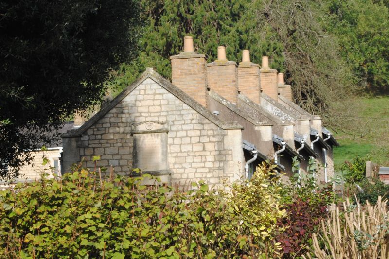
ST 79 SE WOTTON-UNDER-EDGE ADEY'S LANE
3/1 (south)
Bearpackers Almshouses
II
Almshouses. Dated 1818. Squared and coursed dressed stone, ashlar dressings, welsh
slate roof. Two long narrow, separated blocks, forming L; five Cotswold gables to
each. All chimney stacks in brick. Each five-dwelling block with two-light window to
gable and small one-light alongside to upper floor, and three-light under continuous
string to ground floor all with iron casements; hollow chamfer mouldings. Plank doors
(with nail-head pattern to upper block) under four-centred arches beneath string,
dropped labels in form of blank shields, and decorated spandrels containing initials
'A' and 'B'.
Right hand block stepped to slope, each dwelling contained in coped gable. Outermost
gable of each block with commemorative tablet in form of Greek Stele; inscriptions
worn, but refer endowment 1837 five men and five women; restored and rededicated 1967.
Group faces triangular garden contained in brick wall with weathered stone coping, and
two plain iron gates set to large single stone square weathered piers.
Listing NGR: ST7600793558
External links are from the relevant listing authority and, where applicable, Wikidata. Wikidata IDs may be related buildings as well as this specific building. If you want to add or update a link, you will need to do so by editing the Wikidata entry.


Other nearby listed buildings
