Approximate Location Map
Large Map »
Latitude: 51.6384 / 51°38'18"N
Longitude: -2.3546 / 2°21'16"W
OS Eastings: 375555
OS Northings: 193352
OS Grid: ST755933
Mapcode National: GBR 0MD.CHK
Mapcode Global: VH95G.42KT
Plus Code: 9C3VJJQW+95
Entry Name: 1, Bear Street
Listing Date: 16 August 1984
Grade: II
Source: Historic England
Source ID: 1341559
English Heritage Legacy ID: 128042
ID on this website: 101341559
Location: Wotton-under-Edge, Stroud, Gloucestershire, GL12
County: Gloucestershire
District: Stroud
Civil Parish: Wotton-under-Edge
Built-Up Area: Wotton-under-Edge
Traditional County: Gloucestershire
Lieutenancy Area (Ceremonial County): Gloucestershire
Church of England Parish: Wotton-under-Edge with Ozleworth
Church of England Diocese: Gloucester
Tagged with: Building
ST 7693
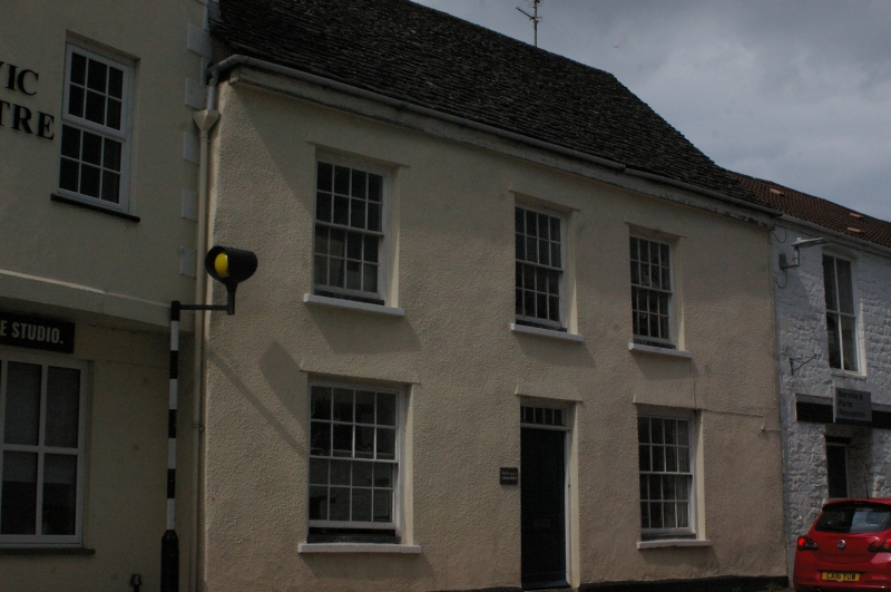
4/3 WOTTON-UNDER-EDGE BEAR STREET
(west)
No. I
II
Terrace dwelling. Late C18. Rendered and ashlared, stone slate roof. Two storeys,
three windowed: modern sashes with glazing bars.
This cottage the only worthy survivor on this side of Bear Street.
Listing NGR: ST7555593352
External links are from the relevant listing authority and, where applicable, Wikidata. Wikidata IDs may be related buildings as well as this specific building. If you want to add or update a link, you will need to do so by editing the Wikidata entry.


Other nearby listed buildings
