Approximate Location Map
Large Map »
Latitude: 51.638 / 51°38'16"N
Longitude: -2.348 / 2°20'52"W
OS Eastings: 376014
OS Northings: 193297
OS Grid: ST760932
Mapcode National: GBR 0MF.76Y
Mapcode Global: VH95G.8325
Plus Code: 9C3VJMQ2+5R
Entry Name: The Ancient Ram Inn
Listing Date: 23 June 1952
Last Amended: 16 May 1996
Grade: II*
Source: Historic England
Source ID: 1088885
English Heritage Legacy ID: 128232
Also known as: Ancient Ram Inn, Wotton-Under-Edge
ID on this website: 101088885
Location: Wotton-under-Edge, Stroud, Gloucestershire, GL12
County: Gloucestershire
District: Stroud
Civil Parish: Wotton-under-Edge
Built-Up Area: Wotton-under-Edge
Traditional County: Gloucestershire
Lieutenancy Area (Ceremonial County): Gloucestershire
Church of England Parish: Wotton-under-Edge with Ozleworth
Church of England Diocese: Gloucester
ST7693 WOTTON-UNDER-EDGE POTTERS POND
(South side)
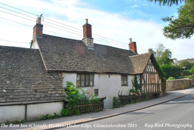
4/161 The Ancient Ram Inn
(Formerly listed as:
23.6.52 Ram Inn)
GV II*
Inn. Late medieval, remodelled in mid/late C16. Rendered limestone rubble with timber-framed rubble; stone slate root; stone stacks with C19 brick flues to right gable end and to ridge; inserted brick stack to left. Original plan form unclear, but probably of the usual3-unit form with through passage dividing hall from service end to left; C16 remodelling included insertion of axial stack against through passage; rectangular-plan outbuilding, probably late C18/early C12 attached to left (east); late C18/early C19 rear wing makes overall L-shaped plan. 2 storeys. Front facing road has chamfered timber lintel to left over C16 studded plank door in chamfered wood surround with depressed 4-centred arch. To left above door is late C16/C17 wood-mullioned ovolo-moulded 4-light window; to right is 2-light window, C17 in origin but reworked later, above C18 3-light wood-mullioned window with shutter hinges and late C16/C17 moulded timber lintel; the right-hand bay has a jettied first-floor timber-framed gable, with close studding and arch bracing to jowled corner posts. To rear elevation are timber lintels over C19 and C20 windows; hipped casement with 6+6-pane casement. Two-storey and later one-storey rear wing has C19 and C20 casements and plank loft door. INTERIOR: late medieval collar-truss roof, with original tenoned collars sawn out and replaced by higher collar; threaded ridge purlin and side purlins with overlapping tenons and soffit spurs; two tiers of windbracing. The roof has been cleaned, and there are no traces of the smoke blackening characteristic of medieval open halls. The hall ceiling has chamfered joists of early form and moulded beams (ogee, hollow and ovolo mouldings), but a complex building history is indicated by morticing for joists in both end beams; open fireplace with stop-chamfered stone jambs and C20 timber lintel. C19 winder stair to rear of main axial stack with late C 16 panelling facing into hall. A narrow beam to the left of the hall stack has chamfered head from original hall door, with masons' mitres to chamfered jamb. Stop-chamfered beams in service room to left. The first floor has 3 chambers with chamfered beams, the parlour to right having windbracing to timber-framed gable end. C17, C18 and C19 doors. The rear wing has collar trusses with truncated tiebeams. Left-hand (east) extension has roof taken from C16 barn.
The lack of smoke blackening to the late medieval trusses and other features indicate that this property may have served as a first-floor hall, its position close to the church suggesting a possible former function as a church house. The presence of tenter hooks, and the documentary links to a series of wool merchants from the C16, are proof of its significance to the local wool trade. Referred to in a deed of1820 as The Ram; deeds dating from 1350 are in Gloucestershire Record Office, refs. DDl193/16/1-2.
Listing NGR: ST7601493297
External links are from the relevant listing authority and, where applicable, Wikidata. Wikidata IDs may be related buildings as well as this specific building. If you want to add or update a link, you will need to do so by editing the Wikidata entry.


Other nearby listed buildings
