Approximate Location Map
Large Map »
Latitude: 51.6395 / 51°38'22"N
Longitude: -2.3531 / 2°21'11"W
OS Eastings: 375660
OS Northings: 193467
OS Grid: ST756934
Mapcode National: GBR 0MD.5XB
Mapcode Global: VH95G.52C0
Plus Code: 9C3VJJQW+QQ
Entry Name: Rowland Hills Almshouses
Listing Date: 16 August 1984
Last Amended: 31 July 1986
Grade: II
Source: Historic England
Source ID: 1088846
English Heritage Legacy ID: 128245
ID on this website: 101088846
Location: Wotton-under-Edge, Stroud, Gloucestershire, GL12
County: Gloucestershire
District: Stroud
Civil Parish: Wotton-under-Edge
Built-Up Area: Wotton-under-Edge
Traditional County: Gloucestershire
Lieutenancy Area (Ceremonial County): Gloucestershire
Church of England Parish: Wotton-under-Edge with Ozleworth
Church of England Diocese: Gloucester
Tagged with: Almshouse
ST 7693 WOTTON-UNDER-EDGE TABERNACLE PITCH
4/175 Nos 1 to 12
(Rowland Mills Alms
houses)
II
The address shall be amended to read;
ST 7693 WOTTON-UNDER-EDGE TABERNACLE PITCH
4/175 Nos 1 to 12
(Rowland Hills Alms
houses)
------------------------------------
ST 7693
4/175 WOTTON-UNDER-EDGE TABERNACLE PITCH
Nos 1 to 12
(Rowland Mills
Almshouses)
II
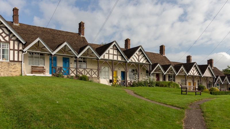
Almshouses. Dated 1887. Smooth rendered, some timber framing, and battened rubble
stone plinth to end pavilions; plain tile roofs. Long narrow row, in three units
stepped to ground slope; continuous open balcony access to single storey units,
fifteen bays in complex rhythm, series of gables, some with open framing. Balcony
rail with cross bracing and standards to gable supports in simple chamfered sections.
Wood casements in three lights and transom; glazing bars to top section first window
only. Simple four-panel doors.
Plaster wall tablet with decorative scrolls in gable end to street records 1887
rebuild of original 1815 foundation; replaced building now known as Streamsfield
(q.v.).
Listing NGR: ST7566093467
External links are from the relevant listing authority and, where applicable, Wikidata. Wikidata IDs may be related buildings as well as this specific building. If you want to add or update a link, you will need to do so by editing the Wikidata entry.


Other nearby listed buildings
