Approximate Location Map
Large Map »
Latitude: 51.6368 / 51°38'12"N
Longitude: -2.1579 / 2°9'28"W
OS Eastings: 389166
OS Northings: 193121
OS Grid: ST891931
Mapcode National: GBR 1P0.78G
Mapcode Global: VH95K.K412
Plus Code: 9C3VJRPR+PR
Entry Name: The Talbot Hotel
Listing Date: 6 September 1954
Grade: II
Source: Historic England
Source ID: 1303881
English Heritage Legacy ID: 128569
ID on this website: 101303881
Location: Tetbury, Cotswold, Gloucestershire, GL8
County: Gloucestershire
District: Cotswold
Civil Parish: Tetbury
Built-Up Area: Tetbury
Traditional County: Gloucestershire
Lieutenancy Area (Ceremonial County): Gloucestershire
Church of England Parish: Tetbury St Mary the Virgin
Church of England Diocese: Gloucester
Tagged with: Hotel
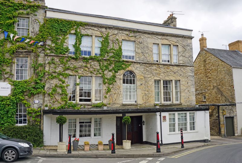
ST 8893-8993 TETBURY MARKET PLACE
(east side)
7/294 No 14 (The Talbot Hotel)
6.9.54
GV II
Hotel. Late C16 core, mainly mid C17 with early C18 front.
Rubble stone with quoins, dressed stone lintels, sill band at 2nd
floor level, cornice and coped blocking course. Cotswold stone
roof with stone and brick stacks. Front range with 2 long rear
ranges, that to right wth 3 cross gables and probably originally
several cottages. Main front of 3 storeys. 3 windows, triple 8-
and 12-pane sashes flanking central semi-circular headed window.
Central entrance originally for pack horses, now with C20 glazed
doors. Portico supported by wooden pillars to left and 2 Roman
Doric pilasters to right with bay filled in between. Right return
has curved wall, probably containing newel stair round fireplace.
Ground floor room to left has C16 doorway in place of chimney and a
thick wall marking probable original building line. Building recorded
as Beerhouse from 1580, as the Talbot from 1685. Beneath gents
toilet to back of left hand wing is large stone water cistern,
about 2m deep, and approx 3m x 4m in size. In cellar in right wing
is deep well with water on surface. Wing to right has 4 chimneys,
some with newel stair. Beyond this wing, stable block with keyed
oculus, now a skittle alley.
Listing NGR: ST8916693121
External links are from the relevant listing authority and, where applicable, Wikidata. Wikidata IDs may be related buildings as well as this specific building. If you want to add or update a link, you will need to do so by editing the Wikidata entry.


Other nearby listed buildings
