Approximate Location Map
Large Map »
Latitude: 51.9901 / 51°59'24"N
Longitude: -1.7422 / 1°44'31"W
OS Eastings: 417798
OS Northings: 232431
OS Grid: SP177324
Mapcode National: GBR 4P8.B9W
Mapcode Global: VHB1H.R7BR
Plus Code: 9C3WX7R5+24
Entry Name: Tithe Barn, Bourton House
Listing Date: 11 January 1985
Grade: I
Source: Historic England
Source ID: 1172027
English Heritage Legacy ID: 128688
Also known as: Tithe barn
ID on this website: 101172027
Location: Bourton-on-the-Hill, Cotswold, Gloucestershire, GL56
County: Gloucestershire
District: Cotswold
Civil Parish: Bourton-on-the-Hill
Traditional County: Gloucestershire
Lieutenancy Area (Ceremonial County): Gloucestershire
Church of England Parish: Bourton-on-the-Hill St Lawrence
Church of England Diocese: Gloucester
Tagged with: Tithe barn
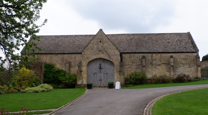
BOURTON-ON-THE-HILL MAIN STREET
SP 1732
(south side)
10/50 Tithe Barn, Bourton House
GV I
Tithe barn. Dated and initialled '1570 R. P.' on stone over main
entrance. Built for Richard Palmer. Ashlar limestone, limestone
slate roof, limestone gable end coping. Plan: rectangular main
body with two central projecting entrance porches in opposition.
Later outshut left of rear porch. Buttressed facade with
projecting plinth. Projecting gabled porch with small C20 plank
double door with cover strips, within larger wooden infill panel
within flat-chamfered 4-centred arch with dated panel with stopped
hood over. Quatrefoil above. Square headed doorway with wood
lintel and C20 glazing in right wall of entrance porch. Slightly
stepped gable end coping with roll-cross saddles.
Interior: 7 bays with original roof timbers comprising tie beam
with struts, collar and clasped purlins. Stone flagged floor
sloping upwards towards right. Small niche with flat-chamfered
ogee niche in wall of main body opposite front entrance porch.
Flat-chamfered square niche in left wall of front entrance
projection.
Listing NGR: SP1779832431
External links are from the relevant listing authority and, where applicable, Wikidata. Wikidata IDs may be related buildings as well as this specific building. If you want to add or update a link, you will need to do so by editing the Wikidata entry.


Other nearby listed buildings
