Approximate Location Map
Large Map »
Latitude: 51.7333 / 51°43'59"N
Longitude: -1.7865 / 1°47'11"W
OS Eastings: 414842
OS Northings: 203863
OS Grid: SP148038
Mapcode National: GBR 4S9.C4X
Mapcode Global: VHB2M.ZPFM
Plus Code: 9C3WP6M7+8C
Entry Name: Knights Mill
Listing Date: 17 June 1986
Grade: II
Source: Historic England
Source ID: 1341037
English Heritage Legacy ID: 129870
ID on this website: 101341037
Location: Quenington, Cotswold, Gloucestershire, GL7
County: Gloucestershire
District: Cotswold
Civil Parish: Quenington
Built-Up Area: Quenington
Traditional County: Gloucestershire
Lieutenancy Area (Ceremonial County): Gloucestershire
Church of England Parish: Coln St Aldwyn St John the Baptist
Church of England Diocese: Gloucester
Tagged with: Mill
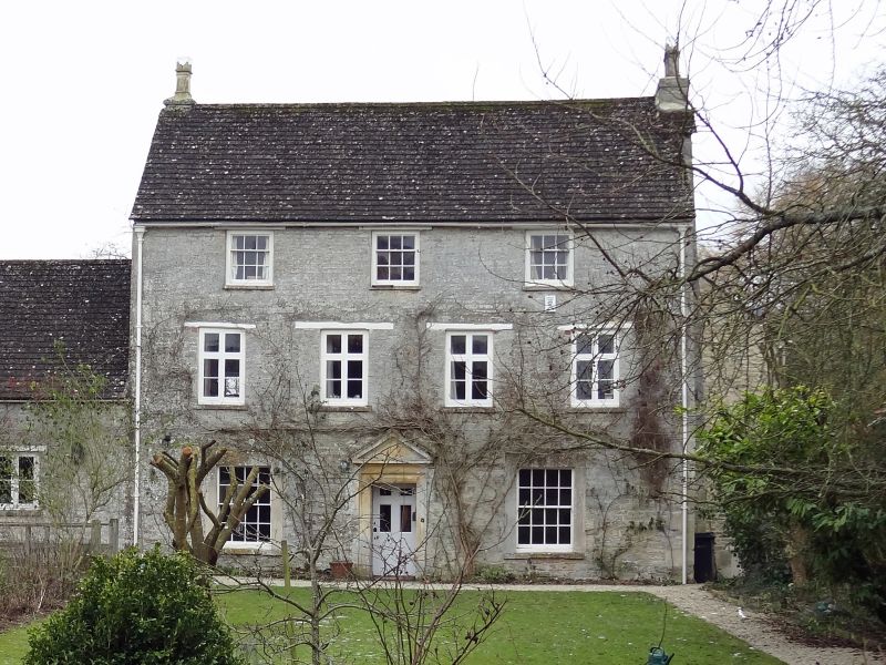
SP 10 SW QUENINGTON CHURCH ROAD
(west side)
6/244 Knights Mill
GV II
Originally probably a C14 fulling mill, in C18 a paper-mill, now
private house. House probably early C17, refronted in C18, with
late C18 or early C19 mill building to left Coursed rubble stone,
concrete tile roof, truncated end stacks to front range and part
external stone stack to C17 rear wing. Single main range of 3
storeys with earlier rear wing of 2 storeys and attic, single
storey mill building forming L shape. Three 9-pane sashes to
second floor, four 2-light wood mullion and transoms to first floor
with timber lintels, 2 large 16-pane sashes in flush stone
surrounds to ground floor flanking central stone doorcase with
moulded architrave, frieze, cornice and pediment and recessed door
of 6 panels, top 4 glazed, lower 2 flush. Rear wing has 3-light
stone mullion with square hoodmould on first floor facing into
angle above large similar with arched lights on ground floor. Mill
building has paired casement with timber lintel over mill leat
adjoining house, and wide 4-light casement with cambered head to
left.
Listing NGR: SP1484603859
External links are from the relevant listing authority and, where applicable, Wikidata. Wikidata IDs may be related buildings as well as this specific building. If you want to add or update a link, you will need to do so by editing the Wikidata entry.


Other nearby listed buildings
