Approximate Location Map
Large Map »
Latitude: 51.7364 / 51°44'11"N
Longitude: -1.7877 / 1°47'15"W
OS Eastings: 414758
OS Northings: 204214
OS Grid: SP147042
Mapcode National: GBR 4S9.4TQ
Mapcode Global: VHB2M.YMS6
Plus Code: 9C3WP6P6+HW
Entry Name: Quenington House
Listing Date: 4 June 1952
Last Amended: 17 June 1986
Grade: II
Source: Historic England
Source ID: 1341055
English Heritage Legacy ID: 129876
ID on this website: 101341055
Location: Quenington, Cotswold, Gloucestershire, GL7
County: Gloucestershire
District: Cotswold
Civil Parish: Quenington
Built-Up Area: Quenington
Traditional County: Gloucestershire
Lieutenancy Area (Ceremonial County): Gloucestershire
Church of England Parish: Coln St Aldwyn St John the Baptist
Church of England Diocese: Gloucester
Tagged with: House
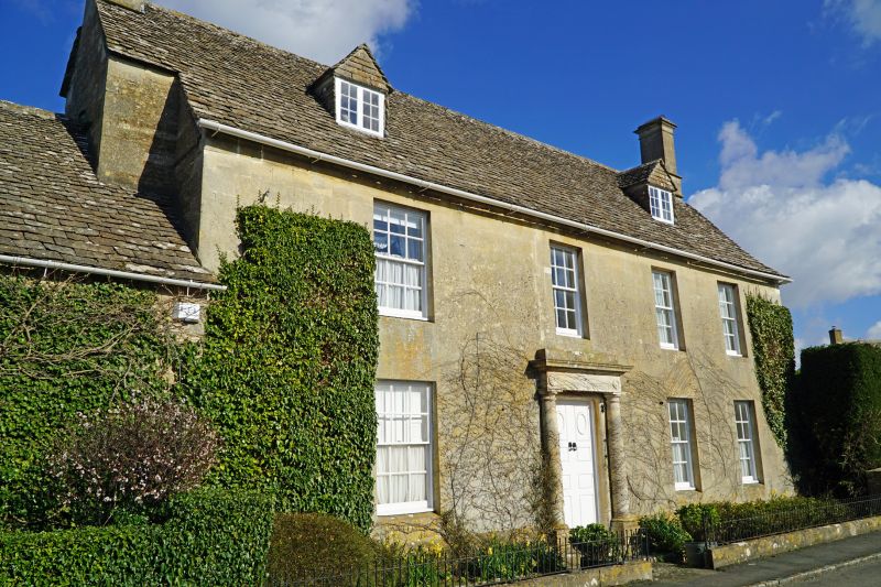
SP 1404-1504 QUENINGTON MAWLEY ROAD
(north side)
12/250 Quenington House
(formerly listed in Back Street)
4.6.52
GV II
Large detached house, recorded in 1862 as a farmhouse on the
Hatherop Estate. Late C18/early C19. Ashlar front with chamfered
plinth and alternating flush quoins, on coursed rubble stone, stone
slate roof, stone end stack to right and external to left, with
offset and moulded cornice. Single front range of 2 storeys and
attic, with 2-storey rear wing to right and single storey rear
section to left, and attached former farmbuilding to left along
street frontage. Four windows, 12-pane sashes in shallow reveals
with sloping flush sills, 3 on ground floor with stone doorcase in
bay 2 from left with attached Doric columns on bases, plain frieze
with roundel over each column, moulded cornice and blocking course.
Double doors of 4 fielded panels each with small oval lights cut
into top pair. Two gabled dormers, set at each end, with stone
slate-hung gables and paired 6-pane casements. Panelling visible
on inside window reveals on ground floor. Outbuilding to left has
3-light wood mullion window at loft level, and left hand gable end
has flight of 10 stone steps up to half-glazed door, recessed with
timber lintel, with four rows of dove holes and stone perches in
apex of gable.
Listing NGR: SP1475804214
External links are from the relevant listing authority and, where applicable, Wikidata. Wikidata IDs may be related buildings as well as this specific building. If you want to add or update a link, you will need to do so by editing the Wikidata entry.


Other nearby listed buildings
