Approximate Location Map
Large Map »
Latitude: 51.74 / 51°44'23"N
Longitude: -2.2716 / 2°16'17"W
OS Eastings: 381342
OS Northings: 204621
OS Grid: SO813046
Mapcode National: GBR 0L5.VXX
Mapcode Global: VH94X.KJYH
Plus Code: 9C3VPPQH+X9
Entry Name: Ryeford Bridge
Listing Date: 24 February 1987
Last Amended: 22 July 2011
Grade: II
Source: Historic England
Source ID: 1172000
English Heritage Legacy ID: 132066
ID on this website: 101172000
Location: Ryeford, Stroud, Gloucestershire, GL10
County: Gloucestershire
District: Stroud
Civil Parish: Stonehouse
Built-Up Area: Stroud
Traditional County: Gloucestershire
Lieutenancy Area (Ceremonial County): Gloucestershire
Church of England Parish: Stonehouse St Cyr
Church of England Diocese: Gloucester
Tagged with: Bridge
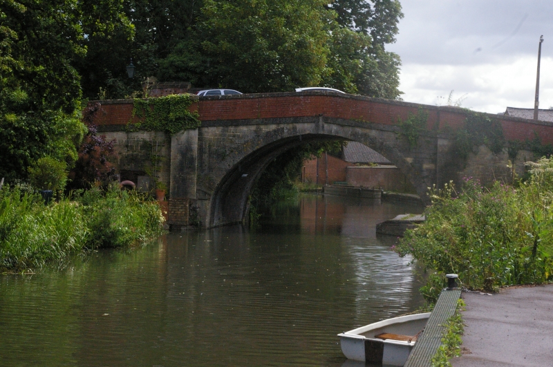
Accommodation bridge over canal. Constructed circa 1779 and widened in about 1833, by the Stroudwater Canal Company.
MATERIALS: it is built mostly handmade red bricks, with coursed and dressed limestone to the west face.
DESCRIPTION: this is a single-span bridge with a semi-circular arched opening. The west side is of coursed limestone up to the inclined stone band, above which is a brick parapet with plain stone coping that appears to have been rebuilt in the second half of the C20. The opposing face is of brick with a flush keystone that cuts through the projecting drip mould, and a brick parapet. The underside of the structure, where the different phases of construction are clearly visible, is also of brick. The wing walls are gently curved and terminate in plain pilasters surmounted by pyramidal caps.
The Stroudwater Navigation, built in 1775-9, was designed to link the River Severn at Framilode to Stroud, allowing coal to be brought from Shropshire, Staffordshire and the Forest of Dean to the textile mills of the Stroud valleys. The Thames and Severn Canal, constructed in 1783-9, was designed to run eastwards from Stroud, eventually linking the River Severn to the River Thames at Inglesham, near Lechlade. The Cotswold Canals, as they are also known, were generally successful, though the Thames and Severn in particular suffered serious technical failings which compromised its profitability; despite this, both canals continued in use well into the C20.
Ryeford Bridge was constructed in circa 1779 by the Stroudwater Canal Company. It is situated on a historic route running north to south between Stonehouse and Kings Stanley. In 1833 the Canal Company widened the canal bridge following difficulties experienced by vehicle traffic due to the narrowness of both the bridge and the adjacent lane.
Ryeford Bridge is designated at Grade II for the following principal reasons:
Historic interest: as a late-C18 structure on the Stroudwater Canal and for its widening in the early C19 which provides evidence for its historical development
Group value: it forms a strong group with other canal-related buildings that are listed and also with the Grade II listed Ryeford House to the north-west
External links are from the relevant listing authority and, where applicable, Wikidata. Wikidata IDs may be related buildings as well as this specific building. If you want to add or update a link, you will need to do so by editing the Wikidata entry.


Other nearby listed buildings
