Approximate Location Map
Large Map »
Latitude: 51.6156 / 51°36'56"N
Longitude: -2.336 / 2°20'9"W
OS Eastings: 376832
OS Northings: 190803
OS Grid: ST768908
Mapcode National: GBR 0MM.Q71
Mapcode Global: VH95G.GNDC
Plus Code: 9C3VJM87+6J
Entry Name: Group of 6 Unidentified Monuments About 2M North of Hale Enclosure, Next to West Wall in Churchyard of Church of St Kenelm
Listing Date: 9 September 1985
Grade: II
Source: Historic England
Source ID: 1340684
English Heritage Legacy ID: 132159
ID on this website: 101340684
Location: St Kenelm's Church, Alderley, Stroud, Gloucestershire, GL12
County: Gloucestershire
District: Stroud
Civil Parish: Alderley
Traditional County: Gloucestershire
Lieutenancy Area (Ceremonial County): Gloucestershire
Church of England Parish: Alderley St Kenelm
Church of England Diocese: Gloucester
Tagged with: Monument
ST 79 SE ALDERLEY ALDERLEY VILLAGE
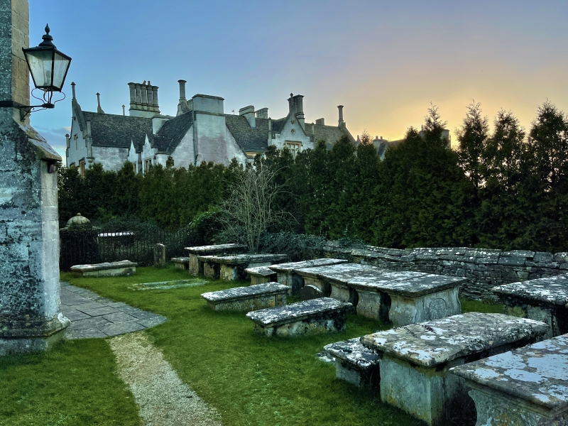
8/14 Group of 6 Unidentified Monuments
about 2m north of Hale enclosure,
next to west wall in churchyard of
Church of St. Kenelm.
GV II
Group of 6 closely set chest tombs. Some or all to Crewe family,
late C17 to early C18. All limestone with flat tops. From south to
north:
1. Heavy moulded capping, plain inscription panel to east
(indecipherable). Breaking up badly on north side at time of
survey (November 1984).
2. Moulded plinth and capping, flattened lyre ends with fielded
panels, long sides divided into 3 fielded panels.
3. and 4. joined together by stone panel and also by iron staples.
Plain ends and sides, very heavy cappings. Inscription on north
dated 1667.
5. Moulded capping rounded to east, plain sides with inscription
to north. Breaking up badly.
6. Moulded capping, colonnettes to 4 corners with fluted end
panels between. Rectangular inscription panels to south and
north with flattened scroll decoration to each side and name of
Edward Crewe, died 1709.
Listing NGR: ST7683290803
External links are from the relevant listing authority and, where applicable, Wikidata. Wikidata IDs may be related buildings as well as this specific building. If you want to add or update a link, you will need to do so by editing the Wikidata entry.


Other nearby listed buildings
