Approximate Location Map
Large Map »
Latitude: 51.7937 / 51°47'37"N
Longitude: -2.4267 / 2°25'36"W
OS Eastings: 370668
OS Northings: 210644
OS Grid: SO706106
Mapcode National: GBR FZ.Y0PX
Mapcode Global: VH875.W5GT
Plus Code: 9C3VQHVF+F8
Entry Name: Vale, Bodnum and Harris Monuments, About 15-20M South-East of South Porch in Churchyard of Church of St Mary
Listing Date: 9 December 1986
Grade: II
Source: Historic England
Source ID: 1152461
English Heritage Legacy ID: 132274
ID on this website: 101152461
Location: St Mary's Church, Arlingham, Stroud, Gloucestershire, GL2
County: Gloucestershire
District: Stroud
Civil Parish: Arlingham
Built-Up Area: Arlingham
Traditional County: Gloucestershire
Lieutenancy Area (Ceremonial County): Gloucestershire
Church of England Parish: Arlingham St Mary the Virgin
Church of England Diocese: Gloucester
Tagged with: Monument
ARLINGHAM CHURCH ROAD
SO 71 SW
(west side)
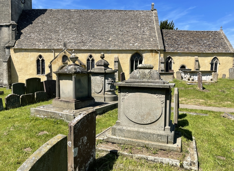
2/16 Vale, Bodnum and Harris Monuments,
about 15-20m south-east of
south porch in churchyard of
Church of St. Mary
GV II
Three pedestal tombs. From north to south: Joseph Vale 1787;
William Bodnum 1809; William Harris 1817. Forest limestone. Vale
and Bodnum are set together on a large base, formerly railed,
partially overgrown and breaking up at time of survey (November
1985). Vale - stepped cap with gadrooned top and acorn finial,
incised edge to flat top, tall moulded plinth, half-round ends.
Reeded frieze with centre rosettes, sides have raised ovals and
palm leaves, west end has wrapped raised oval, east end has high
relief of weeping draped putto under a tree next to a tomb with
urn. Partially overgrown. Bodnum - square, curved pyramidal cap
with reeded urn finial on flat top supported at corners by reeded
columns, broken to south west. Plain plinth, plain sides and ends
with incised headstone shape. Harris (slightly to south east) -
curved pyramidal cap with plain finial on flat top with incised
edge, tall moulded plinth on base which is breaking up. Indented
ends with fluted frieze and rosette and twisted astragal. Ribbon
and plain oval to east, oval with palm leaves to west and larger to
sides.
Listing NGR: SO7066810644
External links are from the relevant listing authority and, where applicable, Wikidata. Wikidata IDs may be related buildings as well as this specific building. If you want to add or update a link, you will need to do so by editing the Wikidata entry.


Other nearby listed buildings
