Approximate Location Map
Large Map »
Latitude: 51.6834 / 51°41'0"N
Longitude: -2.2895 / 2°17'22"W
OS Eastings: 380081
OS Northings: 198334
OS Grid: ST800983
Mapcode National: GBR 0LX.HYR
Mapcode Global: VH953.8YHC
Plus Code: 9C3VMPM6+96
Entry Name: Corn Mill Approximately 80M South East of Owlpen Manor
Listing Date: 23 June 1952
Grade: II
Source: Historic England
Source ID: 1304814
English Heritage Legacy ID: 133151
ID on this website: 101304814
Location: Owlpen, Stroud, Gloucestershire, GL11
County: Gloucestershire
District: Stroud
Civil Parish: Owlpen
Traditional County: Gloucestershire
Lieutenancy Area (Ceremonial County): Gloucestershire
Church of England Parish: Uley with Owlpen and Nympsfield
Church of England Diocese: Gloucester
Tagged with: Mill building
ST 89 NW OWLPEN OWLPEN VILLAGE
6/359 Corn Mill approximately 80m
south east of Owlpen Manor
23.6.52
GV II
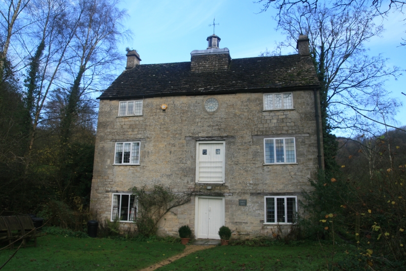
Corn mill, now detached house. 1726. Coursed rubble limestone;
ashlar chimneys; stone slate roof. Three-storey with attic. West
front: 2-window fenestration, all 3-light timber mullioned windows
with leaded iron casements and timber lintels. Central doorway
with plank doors and timber lintel; similar doorway to middle
floor above. Central circular leaded window to upper floor. Plain
gable end chimneys. Central ridge-mounted octagonal timber cupola
with leaded glazing and weathervane; ogee lead top to rectangular
base. Similar casement fenestration to rear.
Interior: although converted to house, many original pieces of
corn milling equipment remain including driving gear, gantry and
sack traps. Continued in use up to 1914, then used to pump water
to Owlpen House high on the escarpment. Mill pond with dam and
sluice gates adjoins on east side.
(C.N. Mander, Owlpen Manor, 1985)
Listing NGR: ST8008198334
External links are from the relevant listing authority and, where applicable, Wikidata. Wikidata IDs may be related buildings as well as this specific building. If you want to add or update a link, you will need to do so by editing the Wikidata entry.


Other nearby listed buildings
