Approximate Location Map
Large Map »
Latitude: 51.7839 / 51°47'2"N
Longitude: -2.2086 / 2°12'31"W
OS Eastings: 385703
OS Northings: 209495
OS Grid: SO857094
Mapcode National: GBR 1M6.0FS
Mapcode Global: VH94R.NFR9
Plus Code: 9C3VQQMR+HG
Entry Name: Washbrook Farm
Listing Date: 24 August 1990
Grade: II
Source: Historic England
Source ID: 1152396
English Heritage Legacy ID: 133302
ID on this website: 101152396
Location: Painswick, Stroud, Gloucestershire, GL6
County: Gloucestershire
District: Stroud
Civil Parish: Painswick
Traditional County: Gloucestershire
Lieutenancy Area (Ceremonial County): Gloucestershire
Church of England Parish: Edge St John the Baptist
Church of England Diocese: Gloucester
Tagged with: Agricultural structure
PAINSWICK HAINES GREEN
SO 80 NE
5/120
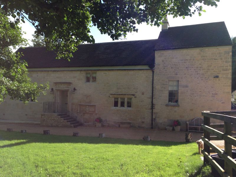
Washbrook Farm
- II
Former mill and mill house, now farmhouse. late C17 or early C18 and mid C19,
possibly with some earlier fabric. Squared and coursed limestone, concrete
tile. A four storey mill building at lower level, and 3-storey narrow mill
house set slightly higher. Downstream front has, left, mainly plain mill house,
with are C20 casement and C20 glazed door to half-basement then 1 + 3 bay mill
with 2 or 3-light recessed chamfer stone-mullioned windows with iron casements,
with stopped hoods at lower ground, ground and first floor, and two 2-light,
without hoods, immediately below eaves; a long C20 dormer with 3 steel casements
extreme right. Centrally a C20 door in chamfered surround, slightly cambered
head to very deep plain stone lintel and hood. Gable, left, has too deep 12-
pane sashes to right, and a C20 casement set to former door opening, left.
Upstream side is 2-storey with basement to mill; the ground level has been
raised by building up both, where centrally there is a blocked and half concealed
door opening with C16 moulded surround and a richly carved lintel including
coat of arms, all under a dropped hood and a bulls-eye plaque in rectangular
setting: to the left of this, up C20 stop with landing a C20 bolection mould
door surround with carved lintel bearing date 1691 and initial HWA. Low right
is half-buried 2-light casement; at main level is a 3-light C20 mullioned casement
a 2-light chamfered mullion at eaves, above blocked door, and a 3-light
with hood over a blocked half-buried similar. At mid-height in C19 extension a
12-pane sash. A stone stack at junction between units. Interior: substantially
modified, many floor changes, no old stair seen. Roof not inspected. A
puzzling building needing more investigation.
Listing NGR: SO8570309495
External links are from the relevant listing authority and, where applicable, Wikidata. Wikidata IDs may be related buildings as well as this specific building. If you want to add or update a link, you will need to do so by editing the Wikidata entry.


Other nearby listed buildings
