Approximate Location Map
Large Map »
Latitude: 51.799 / 51°47'56"N
Longitude: -2.206 / 2°12'21"W
OS Eastings: 385892
OS Northings: 211168
OS Grid: SO858111
Mapcode National: GBR 1M0.147
Mapcode Global: VH94R.Q14Q
Plus Code: 9C3VQQXV+HJ
Entry Name: Holcombe Farmhouse
Listing Date: 4 November 1987
Grade: II
Source: Historic England
Source ID: 1152431
English Heritage Legacy ID: 133310
ID on this website: 101152431
Location: Stroud, Gloucestershire, GL6
County: Gloucestershire
District: Stroud
Civil Parish: Painswick
Traditional County: Gloucestershire
Lieutenancy Area (Ceremonial County): Gloucestershire
Church of England Parish: Edge St John the Baptist
Church of England Diocese: Gloucester
Tagged with: Farmhouse
PAINSWICK HOLCOMBE
SO 81 SE
2/126
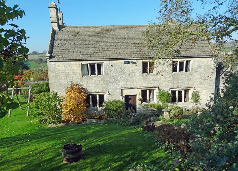
Holcombe Farmhouse
4.11.87
GV II
Farmhouse. Dated 1700 over door, much C19 modification. Coursed and square
dressed limestone, roofs Welsh slate, concrete tile, or concrete slate. A
cross-passage house to which a second parallel range was added on the east side;
this runs full width, giving paired gables and central valley. At the north
end a one storey transverse addition with slate roof. The early, west front,
away from road, two storeys and part cellar, three windows, 3-light at ground
floor, 2-light at first floor and an extra stair light; to the right a sink
panel below window with small cellar opening. Off-centre right doorway to
cross-passage with deep stone lintel to peaked head and a circular panel
inscribed 'SRS MDCC'. All windows and doorway to stopped hoods. left return
double gable has two 3-light casement to common hood at valley level, over
extension with central plank door. Right return also double gable with two 2-
light casements to hoods at each level. To left a large external stack and a
line of flush quoins stones set back from corner. The road (east front)
probably all Cl9, but similar to opposite side, with 3:2:3-light ground floor
and first floor casements with hoods; door off-centre, left under common hood
with central window. All casements recessed hollow chamfer. Gables have
saddle-back copings throughout. Small block to right has two small single
lights. Interior not inspected, but vaulted cellar reported.
Listing NGR: SO8589211168
External links are from the relevant listing authority and, where applicable, Wikidata. Wikidata IDs may be related buildings as well as this specific building. If you want to add or update a link, you will need to do so by editing the Wikidata entry.


Other nearby listed buildings
