Approximate Location Map
Large Map »
Latitude: 51.7863 / 51°47'10"N
Longitude: -2.1949 / 2°11'41"W
OS Eastings: 386654
OS Northings: 209753
OS Grid: SO866097
Mapcode National: GBR 1M0.XKV
Mapcode Global: VH94R.XC0H
Plus Code: 9C3VQRP4+G3
Entry Name: HG Walklett Premises
Listing Date: 21 October 1955
Last Amended: 24 August 1990
Grade: II
Source: Historic England
Source ID: 1090983
English Heritage Legacy ID: 133346
Also known as: H G Walklett Premises
ID on this website: 101090983
Location: Painswick, Stroud, Gloucestershire, GL6
County: Gloucestershire
District: Stroud
Civil Parish: Painswick
Built-Up Area: Painswick
Traditional County: Gloucestershire
Lieutenancy Area (Ceremonial County): Gloucestershire
Church of England Parish: Painswick St Mary the Virgin
Church of England Diocese: Gloucester
SO 8609-8709 (Part)
8/161
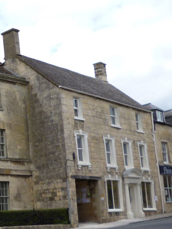
PAINSWICK
NEW STREET (north west side)
H G Walklett premises (formerly listed as Bakers Shop adjoining Beaconsfield House)
GV
II
House with shop. Mid C18, perhaps raised in C19. Squared coursed limestone, concrete tile roof. A symmetrical 3-bay unit with an extra bay to left with large opening to throughway, possibly formerly an inn. Three storeys: ground floor has plain square opening, then two large square openings with eared architraves and two separate keystones (as if for two separate openings), 2-light plate glass casements, flanking door. At first floor 1 + 3 plate glass sashes in eared architraves with keystone and plain cills to consoles; at second floor 3 equally spaced sashes, 12:16:12-pane. Good stone Roman Doric doorcase, with segmental pediment having egg-and-dart enrichment to one of mouldings, containing C20 half-glazed door. Gable stacks, that to right rebuilt. Wing at back has V-joint quoins, and a lofty 2½ storey long wing, with large ridge stack; wing rises up ground slope.
Interior not inspected.
Listing NGR: SO8665609749
External links are from the relevant listing authority and, where applicable, Wikidata. Wikidata IDs may be related buildings as well as this specific building. If you want to add or update a link, you will need to do so by editing the Wikidata entry.


Other nearby listed buildings
