Approximate Location Map
Large Map »
Latitude: 51.7648 / 51°45'53"N
Longitude: -2.1866 / 2°11'11"W
OS Eastings: 387219
OS Northings: 207364
OS Grid: SO872073
Mapcode National: GBR 1MF.60N
Mapcode Global: VH94S.1WWZ
Plus Code: 9C3VQR77+W9
Entry Name: Church of Holy Trinity
Listing Date: 24 August 1990
Grade: II
Source: Historic England
Source ID: 1091579
English Heritage Legacy ID: 133488
ID on this website: 101091579
Location: Holy Trinity Church, Slad, Stroud, Gloucestershire, GL6
County: Gloucestershire
District: Stroud
Civil Parish: Painswick
Built-Up Area: Slad
Traditional County: Gloucestershire
Lieutenancy Area (Ceremonial County): Gloucestershire
Church of England Parish: Uplands All Saints
Church of England Diocese: Gloucester
Tagged with: Church building
PAINSWICK SLAD
SO 80 NE
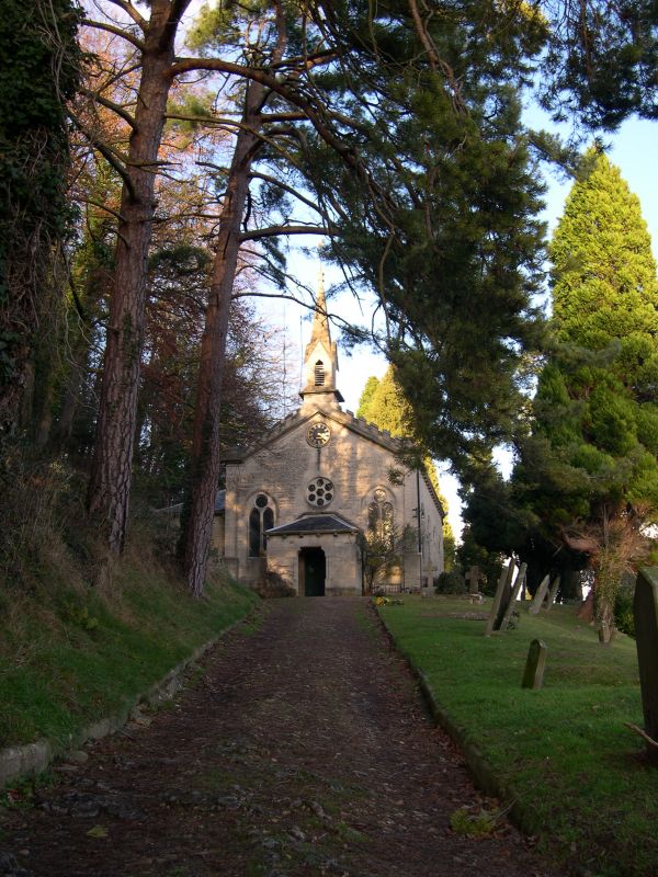
5/297 Church of Holy Trinity
GV II
Anglican Parish Church. 1831, by Charles Baker of Painswick, reconstructed by
Benjamin Bucknell 1869. Ashlar limestone entrance front, squared coursed and
dressed elsewhere. Slate roof. Nave with gable spirelet, west porch, north
aisle, chancel. Low pitched crenellated west gable over two 2-light plate
tracery windows and small central 6-foil rose above hipped porch with shouldered
door opening; corner pilasters, nave, side to road has four 2-light plate
tracery windows, corbel table. Chancel has two small lancets and one triple
lancet. Stone spirelet is square base, ogee opening to each face and octagonal
finish over gablets. Clock below is dated 188-. Has group value with School
and Schoolhouse (q.v.). Interior: 4-bay nave, boarded ceiling in 3 facets,
bracketed principals to stone corbels, pointed barrel to chancel. Deep
embrasure at entrance door under wheel window. Round columns to cushion caps to
4-bay arcade; stone floor, sanctuary rail and pulpit, octagonal font with high
pyramidal capping.
Listing NGR: SO8721907364
External links are from the relevant listing authority and, where applicable, Wikidata. Wikidata IDs may be related buildings as well as this specific building. If you want to add or update a link, you will need to do so by editing the Wikidata entry.


Other nearby listed buildings
