Approximate Location Map
Large Map »
Latitude: 51.9137 / 51°54'49"N
Longitude: -2.0446 / 2°2'40"W
OS Eastings: 397026
OS Northings: 223903
OS Grid: SO970239
Mapcode National: GBR 2LZ.ZVZ
Mapcode Global: VHB1Q.H5YB
Plus Code: 9C3VWX74+F4
Entry Name: The King's Arms
Listing Date: 4 July 1960
Grade: II
Source: Historic England
Source ID: 1091903
English Heritage Legacy ID: 134475
Also known as: The King's Arms, Cheltenham
King's Arms
ID on this website: 101091903
Location: Prestbury, Cheltenham, Gloucestershire, GL52
County: Gloucestershire
District: Cheltenham
Civil Parish: Prestbury
Built-Up Area: Cheltenham
Traditional County: Gloucestershire
Lieutenancy Area (Ceremonial County): Gloucestershire
Church of England Parish: Prestbury St Mary
Church of England Diocese: Gloucester
Tagged with: Pub
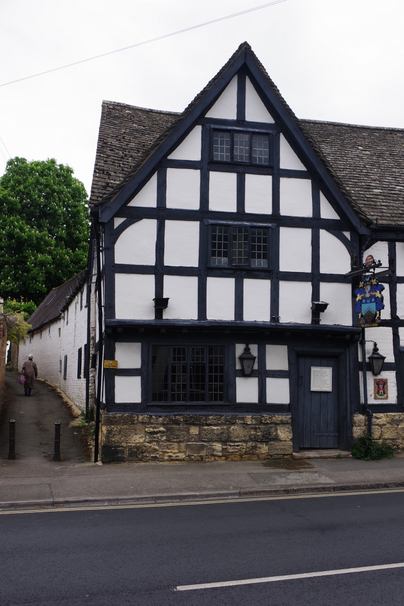
SO 9723 PRESTBURY HIGH STREET
(north side)
20/70 The King's Arms
4.7.60
GV II
Inn. C17 with C18 and C19 extensions. Square-panelled timber-
framing with some curved and some straight bracing and rendered
and painted brick infill. Timber-framing set on a high coursed
squared and dressed limestone plinth. C18 and C19 extensions;
brick and painted brick. Stone slate on roof pitch facing The High
Street, red tile otherwise. Brick stacks. Rectangular plan to
timber-framed range with single bay early C20 extension to right,
C18 and C19 extensions run away at right angles to rear of these.
Timber-framed range; 2 bays, 2½ storeys with jettied gable to
left-hand bay. Jettied gable to left-hand bay. Three and 4-light
casements to early core with leaded panes. Some casements with
early fastenings. Plank door with fillets and an early thumb
latch, within a heavy pegged frame to ground floor jettied section.
Brick-built bay to right with C20 five-light stone-mullioned
casement to ground floor. Two-light casement with leaded panes to
first floor. Access through C20 lean-to porch at right gable end.
Projecting gable-end and axial stacks.
Interior; ceiling beams with deep flat chamfers. Open plan.
Listing NGR: SO9702623903
External links are from the relevant listing authority and, where applicable, Wikidata. Wikidata IDs may be related buildings as well as this specific building. If you want to add or update a link, you will need to do so by editing the Wikidata entry.


Other nearby listed buildings
