Approximate Location Map
Large Map »
Latitude: 52.0462 / 52°2'46"N
Longitude: -2.1736 / 2°10'24"W
OS Eastings: 388190
OS Northings: 238662
OS Grid: SO881386
Mapcode National: GBR 1HY.P9B
Mapcode Global: VH93F.8TRQ
Plus Code: 9C4V2RWG+FH
Entry Name: Milestone
Listing Date: 25 February 1987
Grade: II
Source: Historic England
Source ID: 1091863
English Heritage Legacy ID: 134577
ID on this website: 101091863
Location: Stratfordbridge, Tewkesbury, Gloucestershire, GL20
County: Gloucestershire
District: Tewkesbury
Civil Parish: Twyning
Traditional County: Gloucestershire
Lieutenancy Area (Ceremonial County): Gloucestershire
Church of England Parish: Twyning St Mary Magdalene
Church of England Diocese: Gloucester
Tagged with: Milestone
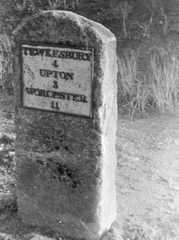
SO 83 NE at TWYNING STRATFORDBRIDGE, A38
NGR 8820 3865 (west side)
1/169 Milestone
II
Milestone. C19. Segmental-headed stone clm in height with a
rectangular cast-iron plaque with 'TEWKESBURY / 4 / UPTON / 3 /
WORCESTER / 11' in raised lettering.
Listing NGR: SO8819038662
External links are from the relevant listing authority and, where applicable, Wikidata. Wikidata IDs may be related buildings as well as this specific building. If you want to add or update a link, you will need to do so by editing the Wikidata entry.


Other nearby listed buildings
