Approximate Location Map
Large Map »
Latitude: 51.841 / 51°50'27"N
Longitude: -2.0511 / 2°3'3"W
OS Eastings: 396575
OS Northings: 215825
OS Grid: SO965158
Mapcode National: GBR 2MY.J8J
Mapcode Global: VHB1X.DZJK
Plus Code: 9C3VRWRX+CH
Entry Name: Wall with Doorways to the South and East of the Church of St Giles
Listing Date: 22 October 1987
Grade: II
Source: Historic England
Source ID: 1091771
English Heritage Legacy ID: 135007
ID on this website: 101091771
Location: Coberley, Cotswold, Gloucestershire, GL53
County: Gloucestershire
District: Cotswold
Civil Parish: Coberley
Traditional County: Gloucestershire
Lieutenancy Area (Ceremonial County): Gloucestershire
Church of England Parish: Coberley St Giles
Church of England Diocese: Gloucester
Tagged with: Wall
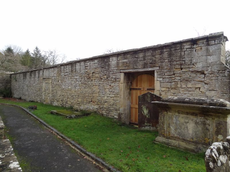
COBERLEY -
SO 91 NE
5/55 Wall with doorways to the south
and east of the Church of
St Giles
GV II
Wall. Probably C17. Coursed squared and dressed limestone faced
in ashlar on the south. 'L'-shaped plan comprising an east - west
and a north - south section both c25m in length. The wall formerly
screened Coberley Court, demolished 1790, from the church and
originally formed part of a more extensive network. Viewed from
the south from left to right: round-headed doorway with a dressed
moulded surround, pulvinated frieze and a triangular pediment which
formerly opened into a walled formal garden to the west of Coberley
Court; early graffiti representing a bearded man; traces of a
return wall formerly running southwards; low round-headed doorway,
now blocked, with a moulded surround, keystone and imposts which
formerly opened into the garden immediately north of Coberley
Court; single-light splayed window with a moulded and lugged
surround to the right; similar window on the east facing side of
the wall close to the corner which has banded rustications.
Battlements with roll-moulded merlons and embrasures remain on part
of the north - south section. (Engraving of c1712 by Kip in
Atkyn's The History of Gloucestershire; also shown in V.C.H.
Gloucestershire, Vol VII)
Listing NGR: SO9657515825
External links are from the relevant listing authority and, where applicable, Wikidata. Wikidata IDs may be related buildings as well as this specific building. If you want to add or update a link, you will need to do so by editing the Wikidata entry.


Other nearby listed buildings
