Approximate Location Map
Large Map »
Latitude: 50.847 / 50°50'49"N
Longitude: -0.9367 / 0°56'12"W
OS Eastings: 474951
OS Northings: 105814
OS Grid: SU749058
Mapcode National: GBR CF1.XML
Mapcode Global: FRA 86XV.QW1
Plus Code: 9C2XR3W7+R8
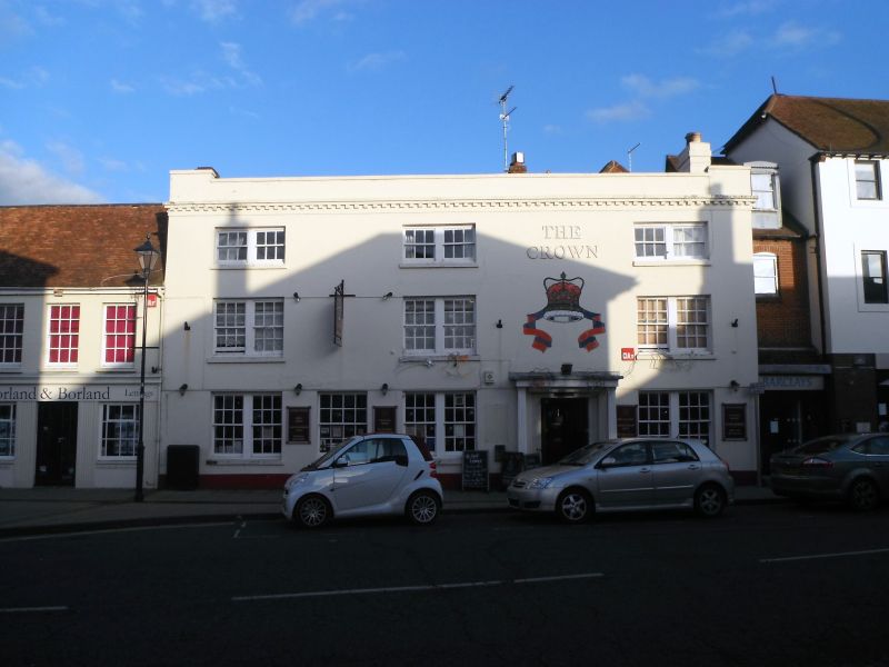
Entry Name: The Crown Public House
Listing Date: 21 July 1975
Grade: II
Source: Historic England
Source ID: 1340179
English Heritage Legacy ID: 135385
ID on this website: 101340179
Location: Emsworth, Havant, Hampshire, PO10
County: Hampshire
District: Havant
Electoral Ward/Division: Emsworth
Parish: Non Civil Parish
Built-Up Area: Emsworth
Traditional County: Hampshire
Lieutenancy Area (Ceremonial County): Hampshire
Church of England Parish: Warblington St Thomas a Becket
Church of England Diocese: Portsmouth
Tagged with: Pub
SU 7405 HAVANT HIGH STREET,
Emsworth (East Side)
21.7.75
11/18 No. 8 (The Crown Public
House).
GV II
Hotel, early C19. Stucco, with a tile roof. 3 storeys, 3 windows. Parapet
with stone coping, brick dentil band, stone cills, plinth. Coupled sashes, in
reveals. Doorway with thin square columns.
Listing NGR: SU7495105814
External links are from the relevant listing authority and, where applicable, Wikidata. Wikidata IDs may be related buildings as well as this specific building. If you want to add or update a link, you will need to do so by editing the Wikidata entry.


Other nearby listed buildings
