Approximate Location Map
Large Map »
Latitude: 50.8979 / 50°53'52"N
Longitude: -1.406 / 1°24'21"W
OS Eastings: 441871
OS Northings: 111103
OS Grid: SU418111
Mapcode National: GBR RQH.DH
Mapcode Global: FRA 76YQ.N2Y
Plus Code: 9C2WVHXV+5J
Entry Name: 8, Bugle Street
Listing Date: 8 October 1981
Grade: II
Source: Historic England
Source ID: 1092061
English Heritage Legacy ID: 135748
ID on this website: 101092061
Location: Southampton, Hampshire, SO14
County: City of Southampton
Electoral Ward/Division: Bargate
Parish: Non Civil Parish
Built-Up Area: Southampton
Traditional County: Hampshire
Lieutenancy Area (Ceremonial County): Hampshire
Church of England Parish: Southampton City Centre St Mary
Church of England Diocese: Winchester
Tagged with: Building
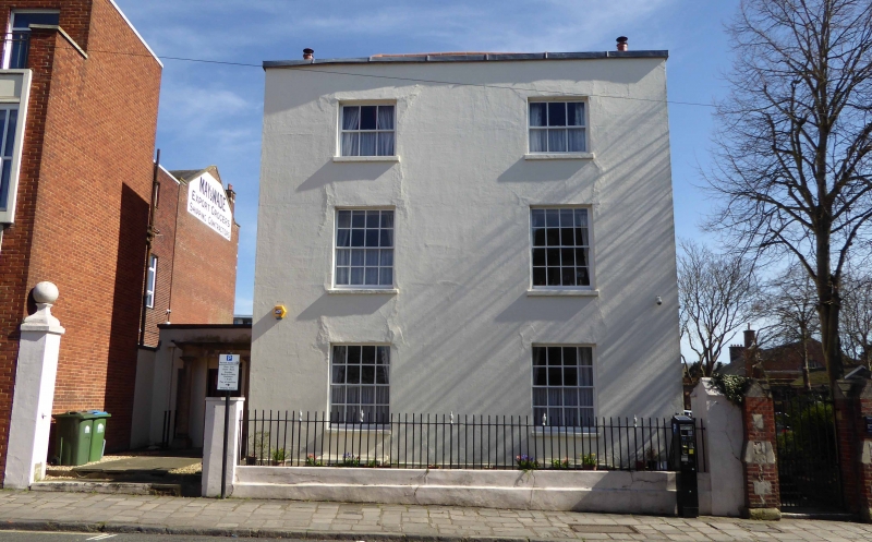
1. BUGLE STREET
5239 (east side)
No 8
SU 4111 3/56
II
2.
Early C19. Three storeys cement-rendered with stone coping. Two sashes with
glazing bars. Later doorcase at side.
Listing NGR: SU4187111103
External links are from the relevant listing authority and, where applicable, Wikidata. Wikidata IDs may be related buildings as well as this specific building. If you want to add or update a link, you will need to do so by editing the Wikidata entry.


Other nearby listed buildings
