Approximate Location Map
Large Map »
Latitude: 50.899 / 50°53'56"N
Longitude: -1.4068 / 1°24'24"W
OS Eastings: 441810
OS Northings: 111225
OS Grid: SU418112
Mapcode National: GBR RQC.L7
Mapcode Global: FRA 76YQ.MR9
Plus Code: 9C2WVHXV+H7
Entry Name: 8, Westgate Street
Listing Date: 14 July 1953
Grade: II
Source: Historic England
Source ID: 1301978
English Heritage Legacy ID: 135971
ID on this website: 101301978
Location: Southampton, Hampshire, SO14
County: City of Southampton
Electoral Ward/Division: Bargate
Parish: Non Civil Parish
Built-Up Area: Southampton
Traditional County: Hampshire
Lieutenancy Area (Ceremonial County): Hampshire
Church of England Parish: Southampton City Centre St Mary
Church of England Diocese: Winchester
Tagged with: Building
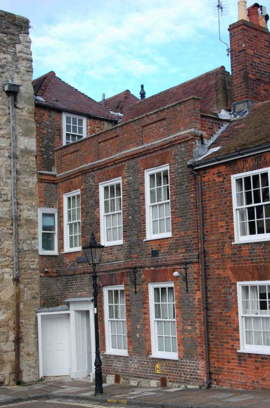
1. WESTGATE STREET 5239
No 8
SU 4111 3/272 14.7.53
II GV
2.
C18. Two storeys grey brick with red brick dressings. Tiled roof. High
parapet with 3 recessed panels, eaves cornice and brick stringcourse at first
floor level. Three sashes. Side doorcase with reeded architrave surround
and flat hood over.
Listing NGR: SU4181011225
External links are from the relevant listing authority and, where applicable, Wikidata. Wikidata IDs may be related buildings as well as this specific building. If you want to add or update a link, you will need to do so by editing the Wikidata entry.


Other nearby listed buildings
