Approximate Location Map
Large Map »
Latitude: 51.2649 / 51°15'53"N
Longitude: -0.8546 / 0°51'16"W
OS Eastings: 480010
OS Northings: 152371
OS Grid: SU800523
Mapcode National: GBR C84.LRB
Mapcode Global: VHDXV.4GKP
Plus Code: 9C3X747W+X5
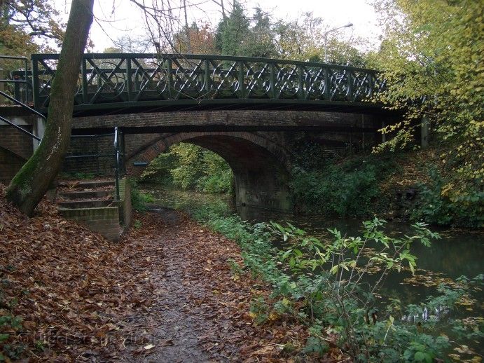
Entry Name: Malthouse Bridge
Listing Date: 13 April 1984
Grade: II
Source: Historic England
Source ID: 1092307
English Heritage Legacy ID: 136600
ID on this website: 101092307
Location: Crookham Village, Hart, Hampshire, GU52
County: Hampshire
District: Hart
Civil Parish: Church Crookham
Built-Up Area: Fleet
Traditional County: Hampshire
Lieutenancy Area (Ceremonial County): Hampshire
Church of England Parish: Crookham
Church of England Diocese: Guildford
Tagged with: Bridge
SU 85 SW FLEET
10/2 Malthouse Bridge
13.4.84
- II
1792. Standard type of bridge, crossing the Basingstoke Canal. A single
cambered arch spanning waterway and towpath. Red brickwork (English bond),
projecting band following slightly-cambered roadway, parapet wall ending in
square piers with plain stone caps. Straight brick cutwaters. Metal ties.
Listing NGR: SU8091954075
External links are from the relevant listing authority and, where applicable, Wikidata. Wikidata IDs may be related buildings as well as this specific building. If you want to add or update a link, you will need to do so by editing the Wikidata entry.


Other nearby listed buildings
