Approximate Location Map
Large Map »
Latitude: 51.2908 / 51°17'26"N
Longitude: -0.888 / 0°53'16"W
OS Eastings: 477636
OS Northings: 155218
OS Grid: SU776552
Mapcode National: GBR C7W.48T
Mapcode Global: VHDXM.KTDB
Plus Code: 9C3X74R6+8Q
Entry Name: Wintney Farm Barn to West of Farmhouse
Listing Date: 8 July 1952
Grade: II*
Source: Historic England
Source ID: 1092276
English Heritage Legacy ID: 136727
ID on this website: 101092276
Location: Hart, Hampshire, RG27
County: Hampshire
District: Hart
Civil Parish: Hartley Wintney
Traditional County: Hampshire
Lieutenancy Area (Ceremonial County): Hampshire
Church of England Parish: Hartley Wintney with Elvetham St John the Evangelist
Church of England Diocese: Winchester
Tagged with: Architectural structure
SU 75 NE HARTLEY WINTNEY
5/77 Wintney Farm Barn to
west of farmhouse
8.7.52
- II*
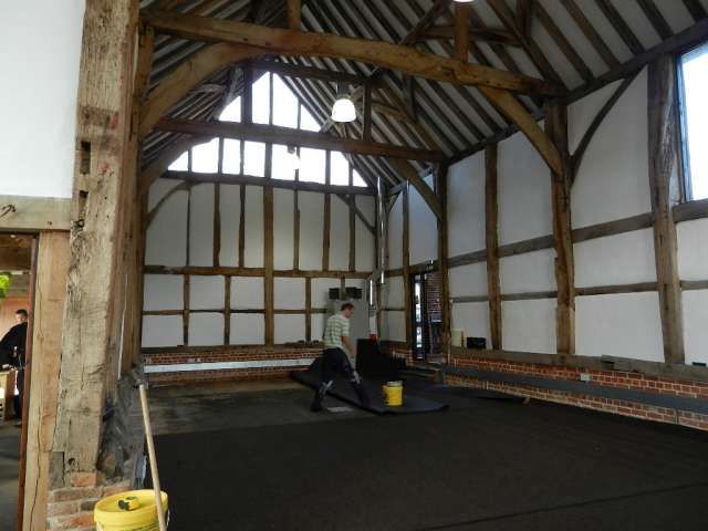
Associated with a Priory of Cistercian nuns founded about 1190. C15, C16.
Large barn of 7 bays, with a central projecting entrance on the west side,
flanked by aisles. Corrugated iron main roof, gabled at each end; aisles and
entrance covered in red tiling. The structure is a massive timber-frame, resting
on a low red brick wall (mostly header bond), with a Queen Post, with arch braces
supporting tie-beams, and from top plate to purlins, the tie-beam from the aisle
eaves to the middle of each post carries a straight strut to a purlin. Main
walling has 2 heavy verticals to each bay, with 3 lighter posts between, with
side girths and double-curved strutting at intervals, with red brick herringbone
infill. The aisle is an open frame, with one bricknogged section. The south
gable is weather boarded except for the lower wall which,is red brickwork
(English bond); the north gable is likewise boarded above a bricknogged exposed
frame. A small brick and tile extension eastwards of the north-east corner
incorporates an old brick wall on its north side.
Listing NGR: SU7737357099
External links are from the relevant listing authority and, where applicable, Wikidata. Wikidata IDs may be related buildings as well as this specific building. If you want to add or update a link, you will need to do so by editing the Wikidata entry.


Other nearby listed buildings
