Approximate Location Map
Large Map »
Latitude: 51.283 / 51°16'58"N
Longitude: -0.9481 / 0°56'53"W
OS Eastings: 473459
OS Northings: 154291
OS Grid: SU734542
Mapcode National: GBR C7T.F3X
Mapcode Global: VHDXS.J04R
Plus Code: 9C3X73M2+6Q
Entry Name: The Holt
Listing Date: 26 June 1987
Grade: II
Source: Historic England
Source ID: 1092223
English Heritage Legacy ID: 136803
ID on this website: 101092223
Location: Holt, Hart, Hampshire, RG27
County: Hampshire
District: Hart
Civil Parish: Hook
Built-Up Area: Hook
Traditional County: Hampshire
Lieutenancy Area (Ceremonial County): Hampshire
Church of England Parish: Hook
Church of England Diocese: Winchester
Tagged with: Building
SU 75 SW HOOK HOLT LANE
8/12 The Holt
-
- II
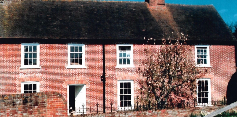
C18. 2 storeys and attic, 4 windows. Red tile roof, brick dentil eaves,
3 gabled dormers on the north side, large chimney attached to the west
gable. Red brick walling in Flemish bond, rubbed flat arches. Upper
casements, 2 good early Victorian ground-floor sashes in exposed frames
(in widened openings). Plain door.
Listing NGR: SP7937349882
External links are from the relevant listing authority and, where applicable, Wikidata. Wikidata IDs may be related buildings as well as this specific building. If you want to add or update a link, you will need to do so by editing the Wikidata entry.


Other nearby listed buildings
