Approximate Location Map
Large Map »
Latitude: 51.2829 / 51°16'58"N
Longitude: -0.9616 / 0°57'41"W
OS Eastings: 472520
OS Northings: 154267
OS Grid: SU725542
Mapcode National: GBR C7S.HQL
Mapcode Global: VHDXS.900T
Plus Code: 9C3X72MQ+59
Entry Name: The White Hart Hotel
Listing Date: 8 July 1952
Grade: II
Source: Historic England
Source ID: 1273235
English Heritage Legacy ID: 136807
ID on this website: 101273235
Location: Hook, Hart, Hampshire, RG27
County: Hampshire
District: Hart
Civil Parish: Hook
Built-Up Area: Hook
Traditional County: Hampshire
Lieutenancy Area (Ceremonial County): Hampshire
Church of England Parish: Hook
Church of England Diocese: Winchester
Tagged with: Hotel
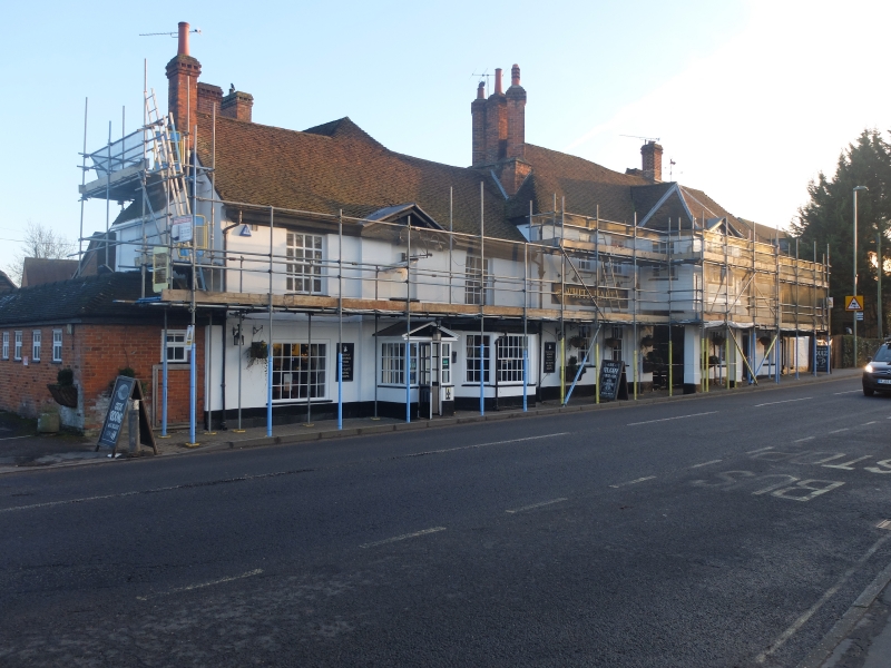
SU 75 SW
8/6
LONDON ROAD, HOOK
The White Hart Hotel
8.7.52
II
C18, early C19. Old Coaching Inn, with buildings around a yard: the front
(Early C19) of 2 storeys in 2 sections. The larger taller western part
(of near-symmetrical form) is dominated by a carriageway entrance with
2 square Doric columns and 2 pilasters, supporting an angular 1st floor
bay, with 2 windows to the east and 3 to the west. Red tile hipped roof,
also hipped bay, with moulded wood eaves cornice: at the east end a massive
rectangular stack has 3 tall flues, the outer ones set diagonally. Stucco
walls. Sashes in reveals. The bay has boarded walling and sash windows,
the central being a Venetian light, with the eaves cornice carried above
as a pediment. The eastern part is of 1.1.1 windows, with a single-storeyed
modern extension. Red tile roof, moulded eaves cornice, formed into a
pediment above the slightly projecting centre. Stucco walls. Large sashes,
a large angular ground-floor bay to the west side. The former central
door is now a sash window and the blank panel above it carries a decorative
wrought-iron sign bracket. The former main entrance retains its large
panelled doors but the only entrance on the front is a plain door in the
centre of the west side. A long 2 storeyed red brick range forms an L-
wing from the west and, finishing in a building with exposed timber-framing.
Within the yard is a granary on staddles, with weather-boarded walls and
a red tile ½-hipped roof.
Listing NGR: SU7252054267
External links are from the relevant listing authority and, where applicable, Wikidata. Wikidata IDs may be related buildings as well as this specific building. If you want to add or update a link, you will need to do so by editing the Wikidata entry.


Other nearby listed buildings
