Approximate Location Map
Large Map »
Latitude: 51.2548 / 51°15'17"N
Longitude: -0.9368 / 0°56'12"W
OS Eastings: 474293
OS Northings: 151164
OS Grid: SU742511
Mapcode National: GBR C86.9Z0
Mapcode Global: VHDXS.QQ3F
Plus Code: 9C3X7337+W7
Entry Name: Fernleigh
Listing Date: 26 June 1987
Grade: II
Source: Historic England
Source ID: 1092172
English Heritage Legacy ID: 136983
ID on this website: 101092172
Location: Odiham, Hart, Hampshire, RG29
County: Hampshire
District: Hart
Civil Parish: Odiham
Built-Up Area: Odiham
Traditional County: Hampshire
Lieutenancy Area (Ceremonial County): Hampshire
Church of England Parish: Odiham All Saints
Church of England Diocese: Winchester
Tagged with: Building
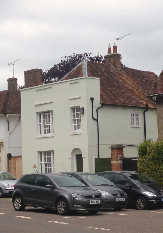
SU 73-7450 & 73-7451 ODIHAM HIGH STREET
(north side)
17/37
No 18
- (Fernleigh)
GV II
C18. 2 storeys, 2 windows. Red tile roof, hipped at the front and rear.
Rendered walling: stone coping to high parapet with recessed panels above
windows, stone cills, plinth. Sashes in reveals, west side windows of 3 lights.
Plain arch to doorway with keystone and impost blocks, 6-panelled door within
architrave.
Listing NGR: SU7428851169
External links are from the relevant listing authority and, where applicable, Wikidata. Wikidata IDs may be related buildings as well as this specific building. If you want to add or update a link, you will need to do so by editing the Wikidata entry.


Other nearby listed buildings
