Approximate Location Map
Large Map »
Latitude: 51.3191 / 51°19'8"N
Longitude: -1.2198 / 1°13'11"W
OS Eastings: 454467
OS Northings: 158067
OS Grid: SU544580
Mapcode National: GBR 94D.BD9
Mapcode Global: VHCZZ.T30L
Plus Code: 9C3W8Q9J+J3
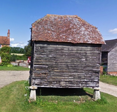
Entry Name: Granary 40 Yards West of the Old House
Listing Date: 18 May 1984
Grade: II
Source: Historic England
Source ID: 1301906
English Heritage Legacy ID: 137982
ID on this website: 101301906
Location: Wolverton, Basingstoke and Deane, Hampshire, RG26
County: Hampshire
District: Basingstoke and Deane
Town: Basingstoke and Deane
Civil Parish: Kingsclere
Traditional County: Hampshire
Lieutenancy Area (Ceremonial County): Hampshire
Church of England Parish: Wolverton with Ewhurst St Catherine
Church of England Diocese: Winchester
Tagged with: Granary
SU 55 NW BAUGHURST RECTORY LANE
8/34
Granary 40 yds west
of The Old House
II
Early C19. Timber frame on 5 staddles. ½-hipped tile roof. Boarded walls.
Listing NGR: SU5665359212
External links are from the relevant listing authority and, where applicable, Wikidata. Wikidata IDs may be related buildings as well as this specific building. If you want to add or update a link, you will need to do so by editing the Wikidata entry.


Other nearby listed buildings
