Approximate Location Map
Large Map »
Latitude: 51.2117 / 51°12'42"N
Longitude: -1.1596 / 1°9'34"W
OS Eastings: 458800
OS Northings: 146173
OS Grid: SU588461
Mapcode National: GBR 95N.TYG
Mapcode Global: VHD0D.VSBY
Plus Code: 9C3W6R6R+M5
Entry Name: Wellhead
Listing Date: 17 October 1984
Grade: II
Source: Historic England
Source ID: 1339505
English Heritage Legacy ID: 138562
ID on this website: 101339505
Location: Dummer, Basingstoke and Deane, Hampshire, RG25
County: Hampshire
District: Basingstoke and Deane
Civil Parish: Dummer
Built-Up Area: Dummer
Traditional County: Hampshire
Lieutenancy Area (Ceremonial County): Hampshire
Church of England Parish: Farleigh
Church of England Diocese: Winchester
Tagged with: Building
SU 54 NE DUMMER WITH KEMPSHOTT DOWN STREET
14/26
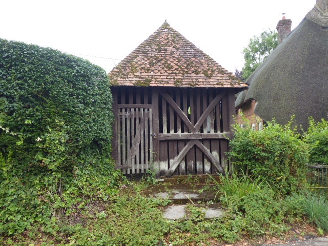
Wellhead
II
1879. Rectangular timber frame with cross-bracing, the lower part having vertical open
weather-boarding the upper of slats. Within is a heavy axle carrying a wide-rimmed
wheel (for working by a dog?). The hipped roof is tiled, with scalloped bands.
Listing NGR: SU5879346178
External links are from the relevant listing authority and, where applicable, Wikidata. Wikidata IDs may be related buildings as well as this specific building. If you want to add or update a link, you will need to do so by editing the Wikidata entry.


Other nearby listed buildings
