Approximate Location Map
Large Map »
Latitude: 51.7181 / 51°43'5"N
Longitude: -2.1873 / 2°11'14"W
OS Eastings: 387157
OS Northings: 202167
OS Grid: SO871021
Mapcode National: GBR 1MZ.CSC
Mapcode Global: VH955.12JR
Plus Code: 9C3VPR97+63
Entry Name: Brimscombe Port Walls
Listing Date: 12 August 2011
Grade: II
Source: Historic England
Source ID: 1399889
ID on this website: 101399889
Location: Brimscombe, Stroud, Gloucestershire, GL5
County: Gloucestershire
District: Stroud
Civil Parish: Brimscombe and Thrupp
Built-Up Area: Stroud
Traditional County: Gloucestershire
Lieutenancy Area (Ceremonial County): Gloucestershire
Church of England Parish: Brimscombe Holy Trinity
Church of England Diocese: Gloucester
Tagged with: Wall
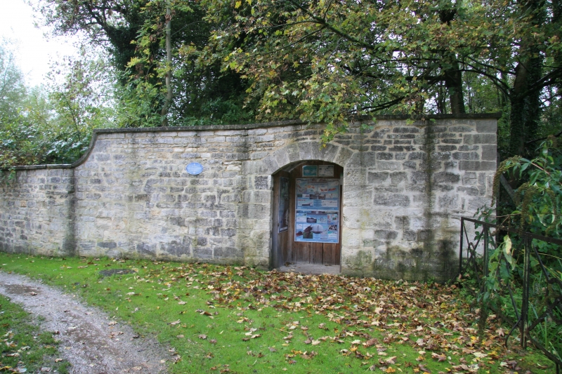
A boundary wall, constructed of local limestone, and dating from the late C18. The wall is of variable height, but mainly approximately 2.3 - 2.5 metres.
MATERIALS: constructed of coursed stone with stone coping.
DESCRIPTION: The principal section of wall is approximately 125 metres in length. It abuts the south bank of the canal at the east entrance to the port, by Bourne Bridge and Lock. A small section of wall, with a doorway, stands on the north bank, also abutting the canal edge. The doorway has a segmental stone head. The section of wall immediately to the south of the canal also has a doorway with stone head, and there are two wrought iron pintles in the left door frame. The bottom pintle is damaged. The wall appears to have been raised by approximately four courses at this location. To the south the wall is of lower height, raised by only two courses, and has ramped coping at one end. The coping stones overhang the top of the wall along its length. The wall curves to the west, following a winding course along a footpath that lines the River Frome. The west end of the wall is attached to a short return section, constructed of brick and stone with a stone render. The structure terminates with the stone pier and capstone that is part of the entranceway to the former foundry.
The Stroudwater Navigation, built in 1775-9, was designed to link the River Severn at Framilode to Stroud, allowing coal to be brought from Shropshire, Staffordshire and the Forest of Dean to the textile mills of the Stroud valleys. The Thames and Severn Canal, constructed in 1783-9, links with the Stroudwater at Wallbridge, and was designed to run eastwards from Stroud, eventually linking the River Severn to the River Thames at Inglesham, near Lechlade. The Cotswold Canals, as they are also known, were generally successful, though the Thames and Severn in particular suffered serious technical failings which compromised its profitability; despite this, both canals continued in use well into the C20.
As an inland transhipment port and the site of the canal company headquarters, Brimscombe Port was the principal focus of activity on the Thames and Severn Canal in the late C18 and C19. The port was constructed in circa 1785, at the time that the canal company built a new road (Brimscombe Hill) from the Cirencester turnpike road on Minchinhampton Common, dropping into the steep valley and the port below. A large port warehouse was built in the north wharf by Thomas Cook of Painswick in 1786-9, and the port wall was probably also constructed around this time (a white wall is shown on a late-C18 watercolour of the port). The port was a busy hub: materials were stored or transhipped between Severn Trows and Thames barges; and mills and foundries were also active on the site. The port wall was built to protect the valuable goods contained within the port buildings and in moored vessels. An engraving of 1826 shows a stone port wall being built or repaired at the west end of the port. The port wall with door entrance that is subject of this assessment is visible in the background of the engraving. The port wall with two entrances is also clearly shown on an engraving from the 1850s. However, the First Edition Ordnance Survey Map of 1884 only shows the doorway on the north bank, and later editions do not specifically show either section.
By the start of the C20, canal traffic declined and some buildings were adapted to new uses: Brimscombe Port warehouse was converted to become Brimscombe Polytechnic in 1911. Activity in the port continued to decline throughout the C20, and many of the port buildings were replaced, and the basin was infilled. The port walls fell into disrepair by the end of the C20, but were restored in 2008. Some small stones with engraved numerals were inserted in the wall during the restoration, as part of a competition run by a local school.
Brimscombe Port Walls, dating from the late-C18, are listed at Grade II, for the following principal reasons:
* Historic interest: as part of the development of the nationally-significant inland transhipment port serving the Thames and Severn Canal
* Intactness: the walls are largely intact, and among the few surviving canal structures at Brimscombe Port
* Group value: the port walls stand in close proximity to Bourne Mills, Bridge and Lock (all listed at Grade II). They mark the eastern boundary of the port that retains Brimscombe Port Mill and the Salt Warehouse (both listed at Grade II).
External links are from the relevant listing authority and, where applicable, Wikidata. Wikidata IDs may be related buildings as well as this specific building. If you want to add or update a link, you will need to do so by editing the Wikidata entry.


Other nearby listed buildings
