Approximate Location Map
Large Map »
Latitude: 50.8555 / 50°51'19"N
Longitude: -2.1674 / 2°10'2"W
OS Eastings: 388312
OS Northings: 106231
OS Grid: ST883062
Mapcode National: GBR 1ZG.BTR
Mapcode Global: FRA 66BV.5FF
Plus Code: 9C2VVR4M+52
Entry Name: World War II Defences: anti-tank cubes and dummy pill box along River Mews and to walled garden south of the Crown Hotel
Listing Date: 5 January 2012
Grade: II
Source: Historic England
Source ID: 1403186
ID on this website: 101403186
Location: Blandford Forum, Dorset, DT11
County: Dorset
Civil Parish: Blandford Forum
Built-Up Area: Blandford Forum
Traditional County: Dorset
Lieutenancy Area (Ceremonial County): Dorset
Church of England Parish: Blandford Forum St Peter and St Paul
Church of England Diocese: Salisbury
Tagged with: Architectural structure
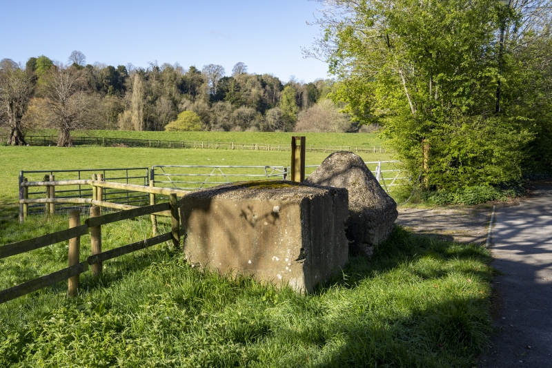
A number of World War II anti-tank obstacles erected in 1940-1 as part of the Blandford Forum Anti-Tank Island.
A number of anti-tank obstacles, erected in c1940-1 as a component of the Blandford Forum Anti-Tank Island, comprising of a pre-existing late-C18/early-C19 brick wall enclosing the rectangular garden south of the Crown Hotel, re-enforced with concrete cubes built against the east wall and a concrete brick faced 'dummy' pill box built against the outside of the south wall.
A further two concrete defence cubes are situated in the car park to the south of the Crown Hotel (the north side of River Mews), and two more, plus one concrete 'dragon tooth' (a cube with a pyramidal cap), stand on the south side of River Mews, at the corner with West Street.
During World War II Blandford Forum lay within the Southern Command defence area under the command of V Corps who were in turn responsible for 50 Division, holding the forward areas of Dorset. In July 1940 V Corps selected the first layout of nodal defence points, designating ten towns as divisional anti-tank islands and prepared them for all-round defence. Amongst these was Blandford Forum, which was also the focal point of the stop-line that ran along the River Stour from Stalbridge to Christchurch. In configuring Blandford Forum as a nodal defence point the creation of obstacles used three basic principles. In the first instance, the existing means of communication in the form of the road and railway bridges over the River Stour were prepared for demolition whilst the road surfaces were prepared for cratering. Secondly, the existing natural obstacle of the River Stour and the man-made obstacles of the cutting and embankments of the Somerset and Dorset Joint Railway were enhanced. The river, which runs from the north-west of the town in a loop along the west side and then along the south side before heading south-east towards Langton Long Blandford, provided considerable defence to the southern and western sides of the town whilst the cutting and embankments of the railway formed the majority of the remainder of the perimeter of the defences on the eastern side of the town. In addition, the existing C18 ha-ha that formed the boundary between Lord Portman's Bryanston Estate and the Borough of Blandford was also strengthened with reinforced concrete to create an anti-tank ditch. As a third measure the natural and man-made defences of the perimeter of the anti-tank island were complemented by the construction of wholly new anti-tank obstacles, mainly in the form of concrete anti-tank blocks, such as for example the row of fifteen concrete cubes to the south-east of Deer Park Holm, White Cliff Mill Street (listed at grade II). Anti-tank obstacles were used to complement the existing railway earthworks on the eastern side of the town, such as those placed beneath the two railway bridges, but the majority were utilised on the western side of the town, in conjunction with the anti-tank ditch. As every anti-tank obstacle was covered by weaponry they were supplemented by a series of pillboxes. Further obstacles were provided in the form of a series of mines that were laid in Crown Meadows and to the east of the railway embankment. The anti-tank island was designed to channel invading forces away from the town itself, to an area of open ground in the north-west which would have been ranged by the Royal Artillery as a 'tank killing ground'. The defences around the town were completed by 24 August 1940. However, the associated stop-line remained unfinished and plans to erect 160 pillboxes and 10 miles of anti-tank ditch were still being considered. By early 1941 it was recognised that the concept of inland linear defence lines demonstrated a total lack of understanding for the modern methods of mechanised warfare and subsequently Southern Command abandoned the system with nodal points becoming the primary defensive positions. The operational life of the defences was short-lived. As early as December 1942, with the threat of invasion receding, defensive positions throughout the country were abandoned either wholly or in part and, as early as 1944, elements of some defences were being cleared.
* Intactness: as good surviving examples of anti-tank defences, one of the most visible components of the Blandford Forum Anti-Tank Island.
* Rarity: as an unusual example of a hidden tank trap with 'dummy' pill box, created by adapting and re-enforcing an existing walled garden.
* Historical Association: as the remains of the World War II military program of inland defence works the blocks can be seen to provide a visual reminder of the impact of world events on Blandford Forum.
* Group Value: in forming part of an important group of other defensive structures known as the Blandford Forum Anti-Tank Island.
External links are from the relevant listing authority and, where applicable, Wikidata. Wikidata IDs may be related buildings as well as this specific building. If you want to add or update a link, you will need to do so by editing the Wikidata entry.


Other nearby listed buildings
