Approximate Location Map
Large Map »
Latitude: 53.5292 / 53°31'45"N
Longitude: -2.2863 / 2°17'10"W
OS Eastings: 381117
OS Northings: 403657
OS Grid: SD811036
Mapcode National: GBR DWGM.TL
Mapcode Global: WH983.VKG8
Plus Code: 9C5VGPH7+MF
Entry Name: Ashworth Grave Slab in Churchyard of Church of St Mary
Listing Date: 21 February 2012
Grade: II
Source: Historic England
Source ID: 1406292
ID on this website: 101406292
Location: St Mary's Church, Prestwich, Bury, Greater Manchester, M25
County: Bury
Electoral Ward/Division: St Mary's
Parish: Non Civil Parish
Built-Up Area: Manchester
Traditional County: Lancashire
Lieutenancy Area (Ceremonial County): Greater Manchester
Church of England Parish: Prestwich St Mary
Church of England Diocese: Manchester
Tagged with: Grave slab
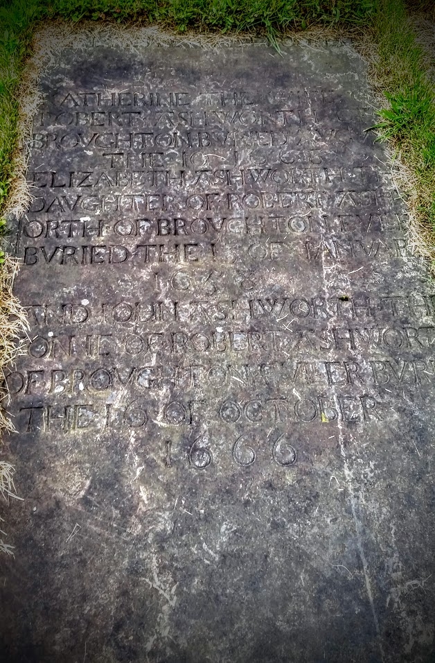
Grave slab commemorating Katherine Ashworth and her children, c1668.
Sandstone, rectangular grave slab located to south side of church. Incised carving including a border. Large incised scroll motif to the foot of the slab with a heart motif above. The inscription reads 'HERE RESTETH THE BODIES OF/ KATHERINE THE WIFE OF/ ROBERT ASHWORTH OF/ BROVGHTON BVRIED AVGVST/ THE 10 1668/ ELIZABETH ASHWORTH THE/ DAVGHTER OF ROBERT ASHW/ ORTH OF BROVGHTON FVLLER/ BVRIED THE 13 OF IANVARY/ 1658/ AND JOHN ASHWORTH THE/ SONNE OF ROBERT ASHWORTH/ OF BROVGHTON FVLLER BVRIED/ THE 16 OF OCTOBER/ 1666.
St Mary's Church, Prestwich, dates to the C14 with later alterations, and the oldest extant grave marker in the churchyard dates to 1641. However, the topography of the churchyard suggests a much older burial ground. The churchyard has been extended many times, including in 1827 when boundary walls were constructed. Prior to these walls being erected the churchyard was enclosed by a ditch and hedge created in 1706, and subsequently by the planting of beech and fir trees in 1763. Further extensions of the churchyard occurred in 1864, 1886, 1924 and 1950.
The western section of the churchyard contains, amongst other graves, the unmarked burials of thousands of inmates of the County Asylum Prestwich dating from the mid-C19 to early-C20, although several communal graves for the asylum's attendants and some inmates are marked by grave slabs. In 1801 a hearse house (altered in the mid-late C20) was constructed to the north of the church.
The Ashworth grave slab, c1668, in St Mary's churchyard, Prestwich, is designated at Grade II for the following principal reasons:
* Early date: It is an increasingly rare survival of a C17 grave slab with an original inscription that remains fully legible
* Imagery: It incorporates an incised scroll motif at the foot of the slab with a carved heart above
* Historic interest: It illustrates the extensive history of the St Mary's churchyard and the original Prestwich-cum-Oldham parish, once one of the largest and wealthiest parishes in the country
* Group value: It has group value with the Grade I listed St Mary's Church and the other listed monuments and structures in the St Mary's churchyard
External links are from the relevant listing authority and, where applicable, Wikidata. Wikidata IDs may be related buildings as well as this specific building. If you want to add or update a link, you will need to do so by editing the Wikidata entry.


Other nearby listed buildings
