Approximate Location Map
Large Map »
Latitude: 53.5297 / 53°31'46"N
Longitude: -2.2864 / 2°17'10"W
OS Eastings: 381114
OS Northings: 403709
OS Grid: SD811037
Mapcode National: GBR DWGM.TF
Mapcode Global: WH983.VJFX
Plus Code: 9C5VGPH7+VF
Entry Name: Hearse House in Churchyard of Church of St Mary
Listing Date: 21 February 2012
Grade: II
Source: Historic England
Source ID: 1406340
ID on this website: 101406340
Location: St Mary's Church, Prestwich, Bury, Greater Manchester, M25
County: Bury
Electoral Ward/Division: St Mary's
Parish: Non Civil Parish
Built-Up Area: Manchester
Traditional County: Lancashire
Lieutenancy Area (Ceremonial County): Greater Manchester
Church of England Parish: Prestwich St Mary
Church of England Diocese: Manchester
Tagged with: Hearse house
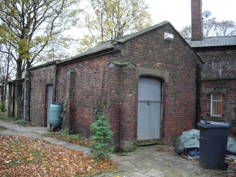
Hearse house, 1801 with later alterations.
MATERIALS: brick with ashlar dressings, slate roof.
EXTERIOR: Hearse house stands to north-east corner of churchyard to north of St Mary's Church. Slender, near full-height gableted piers to south and east elevations, gableted kneelers to eastern gable end. Pitched roof of rear (western) half of building replaced with a flat roof. East gable end with off-centre doorway with a shallow-arched head and ashlar lintel, and a panelled door with a modern metal covering (an identical doorway and door to the west end have been sealed off but can be observed internally). Later narrow doorway inserted to south elevation of rear section. Mid-late C20, single-storey, flat-roofed toilet block extension attached to west end of hearse house with doorways and small windows to south and west elevations is not of special interest.
INTERIOR: Now used as a store. Divided into two (front and rear halves), both with whitewashed walls and stone sett floors. Front section contains an original timber ledger cupboard fixed to one of the walls, an enclosed brick corner stove and chimneybreast. Stone crest, 1668, of Edward Kenyon built into north wall, which came from his monument in St Mary's Church. Interior also incorporates an incised, late medieval stone tomb slab depicting a floriated cross and shears. Wall-mounted hooks to interior of rear section.
St Mary's Church, Prestwich, dates to the C14 with later alterations, and the oldest extant grave marker in the churchyard dates to 1641. However, the topography of the churchyard suggests a much older burial ground. The churchyard has been extended many times, including in 1827 when boundary walls were constructed. Prior to these walls being erected the churchyard was enclosed by a ditch and hedge created in 1706, and subsequently by the planting of beech and fir trees in 1763. Further extensions of the churchyard occurred in 1864, 1886, 1924 and 1950.
The western section of the churchyard contains, amongst other graves, the unmarked burials of thousands of inmates of the County Asylum Prestwich dating from the mid-C19 to early-C20, although several communal graves for the asylum's attendants and some inmates are marked by grave slabs. In 1801 the hearse house (altered in the mid-late C20) was constructed to the north of the church.
The hearse house in St Mary's churchyard, Prestwich, is designated at Grade II for the following principal reasons:
* Date and survival: It is an important survival of a late Georgian hearse house with a design that is above the purely functional, and which despite some later alteration retains many original features, including stone sett floors and a timber ledger cupboard
* Historic interest: Built into the walls of the interior is a 1668 tomb crest and a medieval tomb slab with incised decoration.
* Historical context: It illustrates the extensive history of the St Mary's churchyard and the original Prestwich-cum-Oldham parish, once one of the largest and wealthiest parishes in the country
* Group value: It has group value with the Grade I listed St Mary's Church and the other listed monuments and structures in the St Mary's churchyard
External links are from the relevant listing authority and, where applicable, Wikidata. Wikidata IDs may be related buildings as well as this specific building. If you want to add or update a link, you will need to do so by editing the Wikidata entry.


Other nearby listed buildings
