Approximate Location Map
Large Map »
Latitude: 50.3381 / 50°20'17"N
Longitude: -4.786 / 4°47'9"W
OS Eastings: 201840
OS Northings: 52396
OS Grid: SX018523
Mapcode National: GBR N0.X0FM
Mapcode Global: FRA 08V4.R80
Plus Code: 9C2Q86Q7+6H
Entry Name: Milestone at SX 01840 52396 on Alexandra Road
Listing Date: 21 February 2012
Grade: II
Source: Historic England
Source ID: 1407574
ID on this website: 101407574
Location: St Austell, Cornwall, PL25
County: Cornwall
Civil Parish: St Austell
Built-Up Area: St Austell
Traditional County: Cornwall
Lieutenancy Area (Ceremonial County): Cornwall
Church of England Parish: St Austell
Church of England Diocese: Truro
Tagged with: Milestone
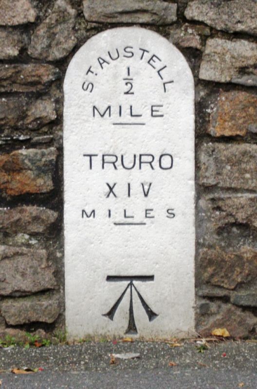
A milestone of c.1870.
A dressed granite milestone that is set into a stone boundary wall on the north side of Alexandra Road. It is rectangular in plan with a rounded top and is approximately 1m high. The road (south) face is inscribed St AUSTELL / ½ / MILE / TRURO / XIV / MILES in relief. The stone itself is painted white with the number picked out in black. An Ordnance Survey benchmark has been inscribed to the lower part of the face.
In 1754, the first Cornish turnpike was established. The next ten years saw the establishment of several new Turnpike Trusts in the county, resulting in the construction of new roads and the erection of milestones. The St Austell and Lostwithiel Turnpike Trust was established by Act of Parliament in 1761 to turnpike the main highway between the Liskeard Roads (turnpiked in the same year) and the Truro Roads. Milestones were erected at one mile intervals from Grampound, where the road met the existing turnpike of the Truro Trust, through St Austell, to Lostwithiel. In about 1870 one of the milestones, situated on Alexandra Road, St Austell, was replaced, probably because the previous milestone had either been damaged or lost.
The St Austell and Lostwithiel Trust was wound up in 1877 and responsibility for its roads was taken over by three different highway boards – Tregony, St Austell and Tywardreath District Highway Boards. The milestone on Alexandra Road is depicted on the first edition Ordnance Survey map of 1880.
The milestone at SX 01840 52396 on Alexandra Road is designated at Grade II for the following principal reasons:
* Intactness: an intact milestone of circa 1870 which remains in its original position;
* Historic Interest: as a replacement for one of the original mid-C18 milestones on this route it demonstrates the continuity of both the turnpike trust and this particular route;
* Group value: with the other listed milestones that were erected by the St Austell and Lostwithiel Trust, one of the earliest turnpike trusts in the county.
External links are from the relevant listing authority and, where applicable, Wikidata. Wikidata IDs may be related buildings as well as this specific building. If you want to add or update a link, you will need to do so by editing the Wikidata entry.


Other nearby listed buildings
